Álvaro Obregón geodata
Álvaro Obregón (Chiapas) is a populated place; located in Mexico in America/Mexico_City (GMT-6) time zone. With population of 1,790 people, there are 4857 cities with bigger population in this country. Compared to other cities in Mexico, 96.9% of cities are located further ↑North; 95.7% of cities are located further ←West and 50.4% of cities have lower elevation than Álvaro Obregón. Note1


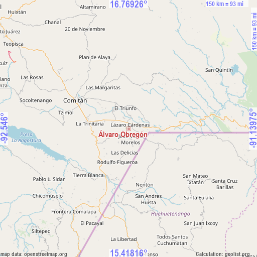
Álvaro Obregón GPS coordinates[2]
16° 5' 41.496" North, 91° 50' 34.332" West
| Map corner | latitude | longitude |
|---|---|---|
| Upper-left | 16.76926°, | -92.546° |
| Center: | 16.09486°, | -91.84287° |
| Lower-right: | 15.41816°, | -91.13975° |
| Map W x H: | 150.2×150.2 km | = 93.3×93.3mi |
| max Lat: | 32.7° ⇑96.9% North |
| Álvaro Obregón: | 16.09486° |
| min Lat: | ⇓3.1% South 14.53588° |
| min Long | Álvaro Obregó | max Long |
| -117.105° | -91.84287° | -86.73105° |
| W 95.7%⇐ | ⇒4.3% E |
Elevation
Elevation of Álvaro Obregón is 1453 m = 4767 ft, and this is 199.3 m = 654 ft above average elevation for this country.
| Max E: |
3497 m = 11473 ft | 49.6% |
| Álvaro Obregón | 1453 m 4767 ft | |
| Avg. | 1253.7 m = 4113 ft | |
Min E: |
-1 m = -3 ft | 50.4% |
See also: Mexico elevation on elevation.city.
Geographical zone
Álvaro Obregón is located in North Torrid zone (between Equator and Tropic of Cancer). Distance of this Northern Tropic circle is 816.3 km =507.2 mi to North.| Distance of | km | miles | from Álvaro Obregón |
|---|---|---|---|
| North Pole | 8217.5 | 5106.1 | to North |
| Arctic Circle | 5611.6 | 3486.9 | to North |
| Tropic Cancer | 816.3 | 507.2 | to North |
| Equator | 1789.6 | 1112 | to South |


Nearby cities:
15 places around Álvaro Obregón: (largest is in red/bold)
• Carmen Xhán
10.9 km =6.8 mi,  121°
121°
• El Porvenir Agrarista
7.8 km =4.8 mi,  5°
5°
• El Progreso
3 km =1.9 mi,  321°
321°
• El Triunfo
12 km =7.5 mi,  351°
351°
• José María Morelos
6 km =3.7 mi,  168°
168°
• La Esperanza
6.9 km =4.3 mi,  336°
336°
• Las Delicias
14.1 km =8.8 mi,  188°
188°
• Lázaro Cárdenas
2.6 km =1.6 mi,  22°
22°
• Miguel Hidalgo
7 km =4.3 mi,  81°
81°
• Ojo de Agua
11.5 km =7.1 mi,  52°
52°
• San Diego
12.9 km =8 mi,  279°
279°
• Unión Juárez
10.3 km =6.4 mi,  291°
291°
• Venustiano Carranza
13.9 km =8.6 mi, 319°
• Vicente Guerrero
10.4 km =6.5 mi, 166°
• Ángel Albino Corzo
9.9 km =6.2 mi,  216°
216°
Sources, notices
• [Note1] Compared only with cities in Mexico existing in our database
• [Src1] Map data: © OpenStreetMap contributors (CC-BY-SA)
• [Src2] Other city data from geonames.org with taken over terms of usage.
• [Src3] Geographical zone / Annual Mean Temperature by Robert A. Rohde @ Wikipedia
