Lázaro Cárdenas geodata
Lázaro Cárdenas (Chiapas) is a populated place; located in Mexico in America/Mexico_City (GMT-6) time zone. With population of 3,699 people, there are 2483 cities with bigger population in this country. Compared to other cities in Mexico, 96.8% of cities are located further ↑North; 95.7% of cities are located further ←West and 53.7% of cities have lower elevation than Lázaro Cárdenas. Note1


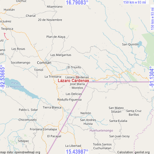
Lázaro Cárdenas GPS coordinates[2]
16° 6' 59.4" North, 91° 50' 0.672" West
| Map corner | latitude | longitude |
|---|---|---|
| Upper-left | 16.79083°, | -92.53665° |
| Center: | 16.1165°, | -91.83352° |
| Lower-right: | 15.43987°, | -91.1304° |
| Map W x H: | 150.2×150.2 km | = 93.3×93.3mi |
| max Lat: | 32.7° ⇑96.8% North |
| Lázaro Cárdenas: | 16.1165° |
| min Lat: | ⇓3.2% South 14.53588° |
| min Long | Lázaro Cárden | max Long |
| -117.105° | -91.83352° | -86.73105° |
| W 95.7%⇐ | ⇒4.3% E |
Elevation
Elevation of Lázaro Cárdenas is 1555 m = 5102 ft, and this is 301.3 m = 989 ft above average elevation for this country.
| Max E: |
3497 m = 11473 ft | 46.3% |
| Lázaro Cárdenas | 1555 m 5102 ft | |
| Avg. | 1253.7 m = 4113 ft | |
Min E: |
-1 m = -3 ft | 53.7% |
See also: Mexico elevation on elevation.city.
Geographical zone
Lázaro Cárdenas is located in North Torrid zone (between Equator and Tropic of Cancer). Distance of this Northern Tropic circle is 813.9 km =505.7 mi to North.| Distance of | km | miles | from Lázaro Cárdenas |
|---|---|---|---|
| North Pole | 8215.1 | 5104.6 | to North |
| Arctic Circle | 5609.2 | 3485.4 | to North |
| Tropic Cancer | 813.9 | 505.7 | to North |
| Equator | 1792 | 1113.5 | to South |


Nearby cities:
15 places around Lázaro Cárdenas: (largest is in red/bold)
• Carmen Xhán
11.6 km =7.2 mi,  134°
134°
• El Porvenir Agrarista
5.4 km =3.4 mi,  357°
357°
• El Progreso
2.9 km =1.8 mi,  268°
268°
• El Triunfo
9.9 km =6.2 mi,  343°
343°
• José María Morelos
8.3 km =5.2 mi,  178°
178°
• La Esperanza
5.4 km =3.4 mi,  316°
316°
• La Patria
15.1 km =9.4 mi,  326°
326°
• Miguel Hidalgo
6.1 km =3.8 mi,  103°
103°
• Ojo de Agua
9.3 km =5.8 mi,  60°
60°
• San Diego
13.7 km =8.5 mi, 268°
• Unión Juárez
10.7 km =6.6 mi,  277°
277°
• Venustiano Carranza
13 km =8.1 mi,  309°
309°
• Vicente Guerrero
12.6 km =7.8 mi,  173°
173°
• Álvaro Obregón
2.6 km =1.6 mi,  202°
202°
• Ángel Albino Corzo
12.5 km =7.8 mi,  213°
213°
Sources, notices
• [Note1] Compared only with cities in Mexico existing in our database
• [Src1] Map data: © OpenStreetMap contributors (CC-BY-SA)
• [Src2] Other city data from geonames.org with taken over terms of usage.
• [Src3] Geographical zone / Annual Mean Temperature by Robert A. Rohde @ Wikipedia
