Miguel Hidalgo geodata
Miguel Hidalgo (Chiapas) is a populated place; located in Mexico in America/Mexico_City (GMT-6) time zone. With population of 2,428 people, there are 3632 cities with bigger population in this country. Compared to other cities in Mexico, 96.9% of cities are located further ↑North; 95.8% of cities are located further ←West and 51.9% of cities have lower elevation than Miguel Hidalgo. Note1


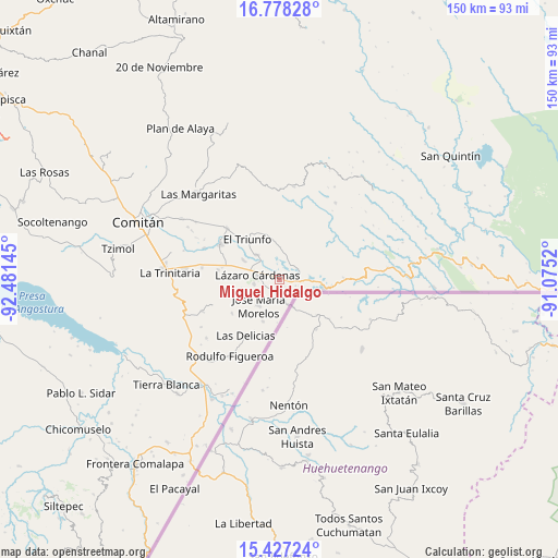
Miguel Hidalgo GPS coordinates[2]
16° 6' 14.076" North, 91° 46' 41.952" West
| Map corner | latitude | longitude |
|---|---|---|
| Upper-left | 16.77828°, | -92.48145° |
| Center: | 16.10391°, | -91.77832° |
| Lower-right: | 15.42724°, | -91.0752° |
| Map W x H: | 150.2×150.2 km | = 93.3×93.3mi |
| max Lat: | 32.7° ⇑96.9% North |
| Miguel Hidalgo: | 16.10391° |
| min Lat: | ⇓3.1% South 14.53588° |
| min Long | Miguel Hidalgo | max Long |
| -117.105° | -91.77832° | -86.73105° |
| W 95.8%⇐ | ⇒4.2% E |
Elevation
Elevation of Miguel Hidalgo is 1522 m = 4993 ft, and this is 268.3 m = 880 ft above average elevation for this country.
| Max E: |
3497 m = 11473 ft | 48.1% |
| Miguel Hidalgo | 1522 m 4993 ft | |
| Avg. | 1253.7 m = 4113 ft | |
Min E: |
-1 m = -3 ft | 51.9% |
See also: Mexico elevation on elevation.city.
Geographical zone
Miguel Hidalgo is located in North Torrid zone (between Equator and Tropic of Cancer). Distance of this Northern Tropic circle is 815.3 km =506.6 mi to North.| Distance of | km | miles | from Miguel Hidalgo |
|---|---|---|---|
| North Pole | 8216.5 | 5105.5 | to North |
| Arctic Circle | 5610.6 | 3486.3 | to North |
| Tropic Cancer | 815.3 | 506.6 | to North |
| Equator | 1790.6 | 1112.6 | to South |


Nearby cities:
15 places around Miguel Hidalgo: (largest is in red/bold)
• Carmen Xhán
7.1 km =4.4 mi,  160°
160°
• El Porvenir Agrarista
9.1 km =5.7 mi,  317°
317°
• El Progreso
8.9 km =5.5 mi,  278°
278°
• El Triunfo
13.9 km =8.6 mi, 321°
• José María Morelos
9 km =5.6 mi,  219°
219°
• La Esperanza
11 km =6.8 mi,  298°
298°
• Lázaro Cárdenas
6.1 km =3.8 mi, 283°
• Ojo de Agua
6.4 km =4 mi,  19°
19°
• San Antonio Buenavista
14.7 km =9.1 mi,  68°
68°
• Santa Elena
16 km =9.9 mi,  359°
359°
• Tierra y Libertad
15.8 km =9.8 mi,  60°
60°
• Tziscao
12.2 km =7.6 mi,  101°
101°
• Vicente Guerrero
12 km =7.5 mi,  201°
201°
• Álvaro Obregón
7 km =4.3 mi,  261°
261°
• Ángel Albino Corzo
15.6 km =9.7 mi,  234°
234°
Sources, notices
• [Note1] Compared only with cities in Mexico existing in our database
• [Src1] Map data: © OpenStreetMap contributors (CC-BY-SA)
• [Src2] Other city data from geonames.org with taken over terms of usage.
• [Src3] Geographical zone / Annual Mean Temperature by Robert A. Rohde @ Wikipedia
