Vega del Rosario geodata
Vega del Rosario (Chiapas) is a populated place; located in Mexico in America/Mexico_City (GMT-6) time zone. With population of 1,014 people, there are 8595 cities with bigger population in this country. Compared to other cities in Mexico, 98.5% of cities are located further ↑North; 93.3% of cities are located further ←West and 60.8% of cities have lower elevation than Vega del Rosario. Note1


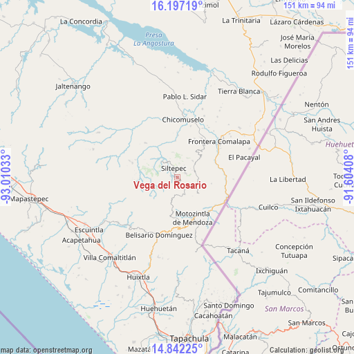
Vega del Rosario GPS coordinates[2]
15° 31' 14.988" North, 92° 18' 25.92" West
| Map corner | latitude | longitude |
|---|---|---|
| Upper-left | 16.19719°, | -93.01033° |
| Center: | 15.52083°, | -92.3072° |
| Lower-right: | 14.84225°, | -91.60408° |
| Map W x H: | 150.7×150.7 km | = 93.6×93.6mi |
| max Lat: | 32.7° ⇑98.5% North |
| Vega del Rosario: | 15.52083° |
| min Lat: | ⇓1.5% South 14.53588° |
| min Long | Vega del Rosari | max Long |
| -117.105° | -92.3072° | -86.73105° |
| W 93.3%⇐ | ⇒6.7% E |
Elevation
Elevation of Vega del Rosario is 1741 m = 5712 ft, and this is 487.3 m = 1599 ft above average elevation for this country.
| Max E: |
3497 m = 11473 ft | 39.2% |
| Vega del Rosario | 1741 m 5712 ft | |
| Avg. | 1253.7 m = 4113 ft | |
Min E: |
-1 m = -3 ft | 60.8% |
See also: Mexico elevation on elevation.city.
Geographical zone
Vega del Rosario is located in North Torrid zone (between Equator and Tropic of Cancer). Distance of this Northern Tropic circle is 880.2 km =546.9 mi to North.| Distance of | km | miles | from Vega del Rosario |
|---|---|---|---|
| North Pole | 8281.3 | 5145.8 | to North |
| Arctic Circle | 5675.4 | 3526.5 | to North |
| Tropic Cancer | 880.2 | 546.9 | to North |
| Equator | 1725.8 | 1072.4 | to South |


Nearby cities:
15 places around Vega del Rosario: (largest is in red/bold)
• Bella Vista
9.5 km =5.9 mi,  42°
42°
• Cumbre Ventanas
3.4 km =2.1 mi,  13°
13°
• El Palmar Grande
6.1 km =3.8 mi,  113°
113°
• El Palmarcito
4.9 km =3 mi,  91°
91°
• El Porvenir de Velasco Suárez
7.7 km =4.8 mi,  157°
157°
• El Rodeo
6.3 km =3.9 mi,  143°
143°
• La Grandeza
8.8 km =5.5 mi,  97°
97°
• La Rinconada
9.1 km =5.7 mi,  27°
27°
• Las Cruces
3.5 km =2.2 mi,  317°
317°
• Las Pilas
8.9 km =5.5 mi, 143°
• Las Salvias
7.6 km =4.7 mi,  178°
178°
• Libertad Ventanas
4 km =2.5 mi,  58°
58°
• Malé
10.1 km =6.3 mi, 141°
• Siltepec
4.4 km =2.7 mi,  337°
337°
• Toquián Grande
5.2 km =3.2 mi,  281°
281°
Sources, notices
• [Note1] Compared only with cities in Mexico existing in our database
• [Src1] Map data: © OpenStreetMap contributors (CC-BY-SA)
• [Src2] Other city data from geonames.org with taken over terms of usage.
• [Src3] Geographical zone / Annual Mean Temperature by Robert A. Rohde @ Wikipedia
