Las Cruces geodata
Las Cruces (Chiapas) is a populated place; located in Mexico in America/Mexico_City (GMT-6) time zone. With population of 556 people, there are 15345 cities with bigger population in this country. Compared to other cities in Mexico, 98.5% of cities are located further ↑North; 93.2% of cities are located further ←West and 51.1% of cities have higher elevation than Las Cruces. Note1


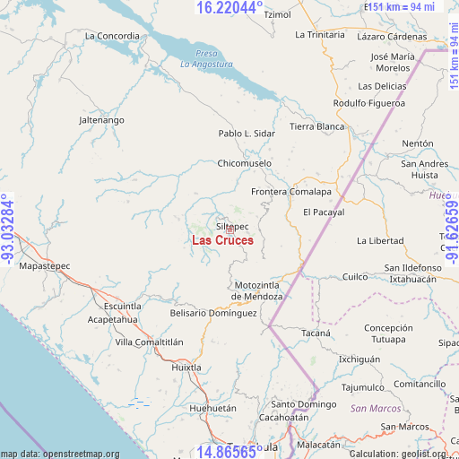
Las Cruces GPS coordinates[2]
15° 32' 38.976" North, 92° 19' 46.956" West
| Map corner | latitude | longitude |
|---|---|---|
| Upper-left | 16.22044°, | -93.03284° |
| Center: | 15.54416°, | -92.32971° |
| Lower-right: | 14.86565°, | -91.62659° |
| Map W x H: | 150.6×150.6 km | = 93.6×93.6mi |
| max Lat: | 32.7° ⇑98.5% North |
| Las Cruces: | 15.54416° |
| min Lat: | ⇓1.5% South 14.53588° |
| min Long | Las Cruces | max Long |
| -117.105° | -92.32971° | -86.73105° |
| W 93.2%⇐ | ⇒6.8% E |
Elevation
Elevation of Las Cruces is 1378 m = 4521 ft, and this is 124.3 m = 408 ft above average elevation for this country.
| Max E: |
3497 m = 11473 ft | 51.1% |
| Las Cruces | 1378 m 4521 ft | |
| Avg. | 1253.7 m = 4113 ft | |
Min E: |
-1 m = -3 ft | 48.9% |
See also: Mexico elevation on elevation.city.
Geographical zone
Las Cruces is located in North Torrid zone (between Equator and Tropic of Cancer). Distance of this Northern Tropic circle is 877.6 km =545.3 mi to North.| Distance of | km | miles | from Las Cruces |
|---|---|---|---|
| North Pole | 8278.7 | 5144.1 | to North |
| Arctic Circle | 5672.8 | 3524.9 | to North |
| Tropic Cancer | 877.6 | 545.3 | to North |
| Equator | 1728.3 | 1073.9 | to South |


Nearby cities:
15 places around Las Cruces: (largest is in red/bold)
• Angel Díaz
7.9 km =4.9 mi,  274°
274°
• Bella Vista
9.9 km =6.2 mi,  63°
63°
• Cumbre Ventanas
3.3 km =2.1 mi,  76°
76°
• El Palmar Grande
9.5 km =5.9 mi,  122°
122°
• El Palmarcito
7.8 km =4.8 mi,  110°
110°
• El Rodeo
9.8 km =6.1 mi,  141°
141°
• La Rinconada
8.6 km =5.3 mi,  50°
50°
• Las Moras
10.7 km =6.6 mi,  278°
278°
• Las Salvias
10.5 km =6.5 mi,  165°
165°
• Libertad Ventanas
5.8 km =3.6 mi,  95°
95°
• Pinada de Arriba
8.2 km =5.1 mi,  5°
5°
• Santo Domingo (La Cascada)
10.3 km =6.4 mi,  231°
231°
• Siltepec
1.6 km =1 mi,  25°
25°
• Toquián Grande
3.1 km =1.9 mi,  238°
238°
• Vega del Rosario
3.5 km =2.2 mi, 137°
Sources, notices
• [Note1] Compared only with cities in Mexico existing in our database
• [Src1] Map data: © OpenStreetMap contributors (CC-BY-SA)
• [Src2] Other city data from geonames.org with taken over terms of usage.
• [Src3] Geographical zone / Annual Mean Temperature by Robert A. Rohde @ Wikipedia
