El Palmar Grande geodata
El Palmar Grande (Chiapas) is a populated place; located in Mexico in America/Mexico_City (GMT-6) time zone. With population of 1,127 people, there are 7691 cities with bigger population in this country. Compared to other cities in Mexico, 98.6% of cities are located further ↑North; 93.7% of cities are located further ←West and 96.1% of cities have lower elevation than El Palmar Grande. Note1


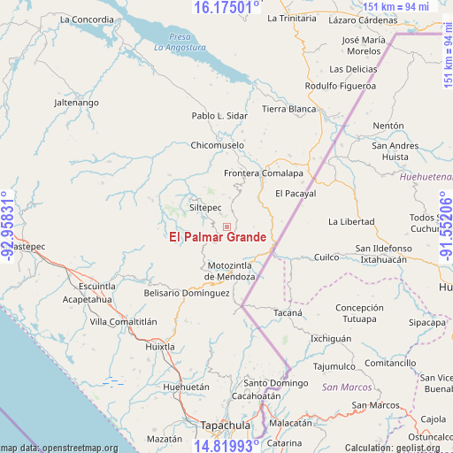
El Palmar Grande GPS coordinates[2]
15° 29' 54.888" North, 92° 15' 18.648" West
| Map corner | latitude | longitude |
|---|---|---|
| Upper-left | 16.17501°, | -92.95831° |
| Center: | 15.49858°, | -92.25518° |
| Lower-right: | 14.81993°, | -91.55206° |
| Map W x H: | 150.7×150.7 km | = 93.6×93.6mi |
| max Lat: | 32.7° ⇑98.6% North |
| El Palmar Grande: | 15.49858° |
| min Lat: | ⇓1.4% South 14.53588° |
| min Long | El Palmar Grand | max Long |
| -117.105° | -92.25518° | -86.73105° |
| W 93.7%⇐ | ⇒6.3% E |
Elevation
Elevation of El Palmar Grande is 2630 m = 8629 ft, and this is 1376.3 m = 4515 ft above average elevation for this country.
| Max E: |
3497 m = 11473 ft | 3.9% |
| El Palmar Grande | 2630 m 8629 ft | |
| Avg. | 1253.7 m = 4113 ft | |
Min E: |
-1 m = -3 ft | 96.1% |
See also: Mexico elevation on elevation.city.
Geographical zone
El Palmar Grande is located in North Torrid zone (between Equator and Tropic of Cancer). Distance of this Northern Tropic circle is 882.6 km =548.4 mi to North.| Distance of | km | miles | from El Palmar Grande |
|---|---|---|---|
| North Pole | 8283.8 | 5147.3 | to North |
| Arctic Circle | 5677.9 | 3528.1 | to North |
| Tropic Cancer | 882.6 | 548.4 | to North |
| Equator | 1723.3 | 1070.8 | to South |


Nearby cities:
15 places around El Palmar Grande: (largest is in red/bold)
• Bella Vista
9.5 km =5.9 mi,  5°
5°
• Canadá
6.4 km =4 mi,  151°
151°
• Cumbre Ventanas
7.5 km =4.7 mi,  320°
320°
• El Palmarcito
2.4 km =1.5 mi,  343°
343°
• El Porvenir de Velasco Suárez
5.3 km =3.3 mi,  209°
209°
• El Rodeo
3.2 km =2 mi,  215°
215°
• La Grandeza
3.4 km =2.1 mi,  67°
67°
• Las Cruces
9.5 km =5.9 mi,  302°
302°
• Las Pilas
4.7 km =2.9 mi,  183°
183°
• Las Salvias
7.4 km =4.6 mi,  226°
226°
• Libertad Ventanas
5.1 km =3.2 mi,  334°
334°
• Malé
5.5 km =3.4 mi,  172°
172°
• Nueva Esperanza Uno
6.4 km =4 mi, 168°
• Ojo de Agua Centro
8.8 km =5.5 mi,  90°
90°
• Vega del Rosario
6.1 km =3.8 mi,  293°
293°
Sources, notices
• [Note1] Compared only with cities in Mexico existing in our database
• [Src1] Map data: © OpenStreetMap contributors (CC-BY-SA)
• [Src2] Other city data from geonames.org with taken over terms of usage.
• [Src3] Geographical zone / Annual Mean Temperature by Robert A. Rohde @ Wikipedia
