La Grandeza geodata
La Grandeza (Chiapas) is a seat of a second-order administrative division; located in Mexico in America/Mexico_City (GMT-6) time zone. With population of 1,044 people, there are 8345 cities with bigger population in this country. Compared to other cities in Mexico, 98.5% of cities are located further ↑North; 93.9% of cities are located further ←West and 71.6% of cities have lower elevation than La Grandeza. Note1


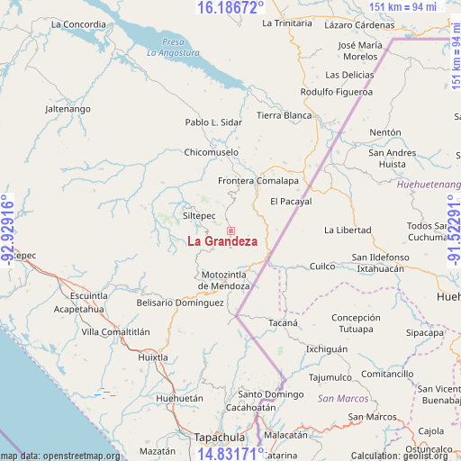
La Grandeza GPS coordinates[2]
15° 30' 37.188" North, 92° 13' 33.708" West
| Map corner | latitude | longitude |
|---|---|---|
| Upper-left | 16.18672°, | -92.92916° |
| Center: | 15.51033°, | -92.22603° |
| Lower-right: | 14.83171°, | -91.52291° |
| Map W x H: | 150.7×150.7 km | = 93.6×93.6mi |
| max Lat: | 32.7° ⇑98.5% North |
| La Grandeza: | 15.51033° |
| min Lat: | ⇓1.5% South 14.53588° |
| min Long | La Grandeza | max Long |
| -117.105° | -92.22603° | -86.73105° |
| W 93.9%⇐ | ⇒6.1% E |
Elevation
Elevation of La Grandeza is 1959 m = 6427 ft, and this is 705.3 m = 2314 ft above average elevation for this country.
| Max E: |
3497 m = 11473 ft | 28.4% |
| La Grandeza | 1959 m 6427 ft | |
| Avg. | 1253.7 m = 4113 ft | |
Min E: |
-1 m = -3 ft | 71.6% |
See also: Mexico elevation on elevation.city.
Geographical zone
La Grandeza is located in North Torrid zone (between Equator and Tropic of Cancer). Distance of this Northern Tropic circle is 881.3 km =547.6 mi to North.| Distance of | km | miles | from La Grandeza |
|---|---|---|---|
| North Pole | 8282.5 | 5146.5 | to North |
| Arctic Circle | 5676.6 | 3527.3 | to North |
| Tropic Cancer | 881.3 | 547.6 | to North |
| Equator | 1724.6 | 1071.6 | to South |


Nearby cities:
15 places around La Grandeza: (largest is in red/bold)
• Bella Vista
8.4 km =5.2 mi,  344°
344°
• Canadá
6.9 km =4.3 mi,  180°
180°
• El Palmar Grande
3.4 km =2.1 mi,  247°
247°
• El Palmarcito
3.9 km =2.4 mi,  284°
284°
• El Porvenir de Velasco Suárez
8.3 km =5.2 mi,  224°
224°
• El Rodeo
6.3 km =3.9 mi,  231°
231°
• La Montaña
8 km =5 mi,  30°
30°
• Las Pilas
6.9 km =4.3 mi,  209°
209°
• Libertad Ventanas
6.2 km =3.9 mi,  301°
301°
• Malé
7.2 km =4.5 mi,  199°
199°
• Monte Ordóñez
8.2 km =5.1 mi,  45°
45°
• Nueva Esperanza Uno
7.8 km =4.8 mi,  193°
193°
• Ojo de Agua Centro
5.8 km =3.6 mi,  104°
104°
• Ojo de Agua Grande
7.2 km =4.5 mi,  108°
108°
• Unión Progreso
8.5 km =5.3 mi,  357°
357°
Sources, notices
• [Note1] Compared only with cities in Mexico existing in our database
• [Src1] Map data: © OpenStreetMap contributors (CC-BY-SA)
• [Src2] Other city data from geonames.org with taken over terms of usage.
• [Src3] Geographical zone / Annual Mean Temperature by Robert A. Rohde @ Wikipedia
