Tzicatlán geodata
Tzicatlán (Veracruz) is a populated place; located in Mexico in America/Mexico_City (GMT-6) time zone. With population of 1,122 people, there are 7736 cities with bigger population in this country. Compared to other cities in Mexico, 71.3% of cities are located further ↓South; 60.7% of cities are located further ←West and 72.5% of cities have higher elevation than Tzicatlán. Note1


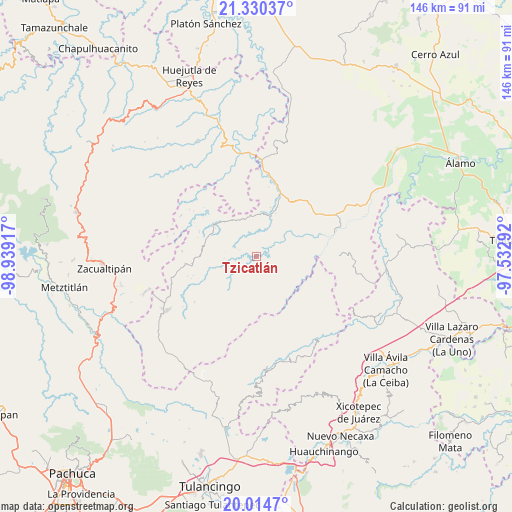
Tzicatlán GPS coordinates[2]
20° 40' 26.256" North, 98° 14' 9.744" West
| Map corner | latitude | longitude |
|---|---|---|
| Upper-left | 21.33037°, | -98.93917° |
| Center: | 20.67396°, | -98.23604° |
| Lower-right: | 20.0147°, | -97.53292° |
| Map W x H: | 146.3×146.3 km | = 90.9×90.9mi |
| max Lat: | 32.7° ⇑28.7% North |
| Tzicatlán: | 20.67396° |
| min Lat: | ⇓71.3% South 14.53588° |
| min Long | Tzicatlán | max Long |
| -117.105° | -98.23604° | -86.73105° |
| W 60.7%⇐ | ⇒39.3% E |
Elevation
Elevation of Tzicatlán is 311 m = 1020 ft, and this is 942.7 m = 3093 ft below average elevation for this country.
| Max E: |
3497 m = 11473 ft | 72.5% |
| Avg. | 1253.7 m = 4113 ft | |
| Tzicatlán | 311 m = 1020 ft | |
Min E: |
-1 m = -3 ft | 27.5% |
See also: Mexico elevation on elevation.city.
Geographical zone
Tzicatlán is located in North Torrid zone (between Equator and Tropic of Cancer). Distance of this Northern Tropic circle is 307.2 km =190.9 mi to North.| Distance of | km | miles | from Tzicatlán |
|---|---|---|---|
| North Pole | 7708.3 | 4789.7 | to North |
| Arctic Circle | 5102.4 | 3170.5 | to North |
| Tropic Cancer | 307.2 | 190.9 | to North |
| Equator | 2298.7 | 1428.3 | to South |


Nearby cities:
15 places around Tzicatlán: (largest is in red/bold)
• Ayotuxtla
7.5 km =4.7 mi,  248°
248°
• Chintipán
5.5 km =3.4 mi,  106°
106°
• El Mamey
12.6 km =7.8 mi,  328°
328°
• El Naranjal
9.6 km =6 mi,  50°
50°
• El Pericón
4 km =2.5 mi,  208°
208°
• Jonotal Azteca
13.6 km =8.5 mi,  90°
90°
• La Candelaria
14 km =8.7 mi,  317°
317°
• La Florida
13.8 km =8.6 mi,  230°
230°
• La Mirra
13 km =8.1 mi, 246°
• Limontitla
7 km =4.3 mi,  0°
0°
• Otatitlán
10.9 km =6.8 mi, 113°
• Otlatzintla
11.8 km =7.3 mi,  353°
353°
• Tetzacual
11.6 km =7.2 mi,  342°
342°
• Tierra Colorada
5.4 km =3.4 mi,  134°
134°
• Tlachichilco
7 km =4.3 mi,  146°
146°
Sources, notices
• [Note1] Compared only with cities in Mexico existing in our database
• [Src1] Map data: © OpenStreetMap contributors (CC-BY-SA)
• [Src2] Other city data from geonames.org with taken over terms of usage.
• [Src3] Geographical zone / Annual Mean Temperature by Robert A. Rohde @ Wikipedia
