Otatitlán geodata
Otatitlán (Veracruz) is a populated place; located in Mexico in America/Mexico_City (GMT-6) time zone. With population of 1,727 people, there are 5025 cities with bigger population in this country. Compared to other cities in Mexico, 70.6% of cities are located further ↓South; 62.1% of cities are located further ←West and 67.6% of cities have higher elevation than Otatitlán. Note1


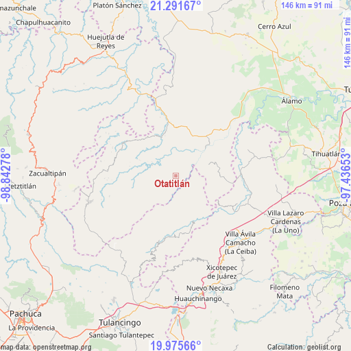
Otatitlán GPS coordinates[2]
20° 38' 6.324" North, 98° 8' 22.74" West
| Map corner | latitude | longitude |
|---|---|---|
| Upper-left | 21.29167°, | -98.84278° |
| Center: | 20.63509°, | -98.13965° |
| Lower-right: | 19.97566°, | -97.43653° |
| Map W x H: | 146.3×146.3 km | = 90.9×90.9mi |
| max Lat: | 32.7° ⇑29.4% North |
| Otatitlán: | 20.63509° |
| min Lat: | ⇓70.6% South 14.53588° |
| min Long | Otatitlán | max Long |
| -117.105° | -98.13965° | -86.73105° |
| W 62.1%⇐ | ⇒37.9% E |
Elevation
Elevation of Otatitlán is 549 m = 1801 ft, and this is 704.7 m = 2312 ft below average elevation for this country.
| Max E: |
3497 m = 11473 ft | 67.6% |
| Avg. | 1253.7 m = 4113 ft | |
| Otatitlán | 549 m = 1801 ft | |
Min E: |
-1 m = -3 ft | 32.4% |
See also: Mexico elevation on elevation.city.
Geographical zone
Otatitlán is located in North Torrid zone (between Equator and Tropic of Cancer). Distance of this Northern Tropic circle is 311.5 km =193.6 mi to North.| Distance of | km | miles | from Otatitlán |
|---|---|---|---|
| North Pole | 7712.7 | 4792.4 | to North |
| Arctic Circle | 5106.8 | 3173.2 | to North |
| Tropic Cancer | 311.5 | 193.6 | to North |
| Equator | 2294.4 | 1425.7 | to South |


Nearby cities:
15 places around Otatitlán: (largest is in red/bold)
• Chintipán
5.5 km =3.4 mi,  300°
300°
• El Naranjal
10.8 km =6.7 mi,  345°
345°
• El Pericón
11.9 km =7.4 mi,  273°
273°
• El Zapote Bravo
14.9 km =9.3 mi,  78°
78°
• Ixhuatlán de Madero
14.6 km =9.1 mi,  65°
65°
• Jonotal Azteca
5.4 km =3.4 mi,  41°
41°
• Juntas Chicas
13.2 km =8.2 mi,  120°
120°
• Limontitla
15.1 km =9.4 mi,  318°
318°
• San Andrés
15.4 km =9.6 mi,  162°
162°
• San Esteban
13 km =8.1 mi,  140°
140°
• San Lorenzo Achiotepec
8.5 km =5.3 mi, 119°
• Tenantitla
15 km =9.3 mi,  358°
358°
• Tierra Colorada
6.2 km =3.9 mi,  275°
275°
• Tlachichilco
6.4 km =4 mi,  255°
255°
• Tzicatlán
10.9 km =6.8 mi,  293°
293°
Sources, notices
• [Note1] Compared only with cities in Mexico existing in our database
• [Src1] Map data: © OpenStreetMap contributors (CC-BY-SA)
• [Src2] Other city data from geonames.org with taken over terms of usage.
• [Src3] Geographical zone / Annual Mean Temperature by Robert A. Rohde @ Wikipedia
