Tuxtla geodata
Tuxtla (Chiapas) is a seat of a first-order administrative division; located in Mexico in America/Mexico_City (GMT-6) time zone. With population of 537,102 people, there are 34 cities with bigger population in this country. Compared to other cities in Mexico, 92.2% of cities are located further ↑North; 88% of cities are located further ←West and 68.1% of cities have higher elevation than Tuxtla. Note1


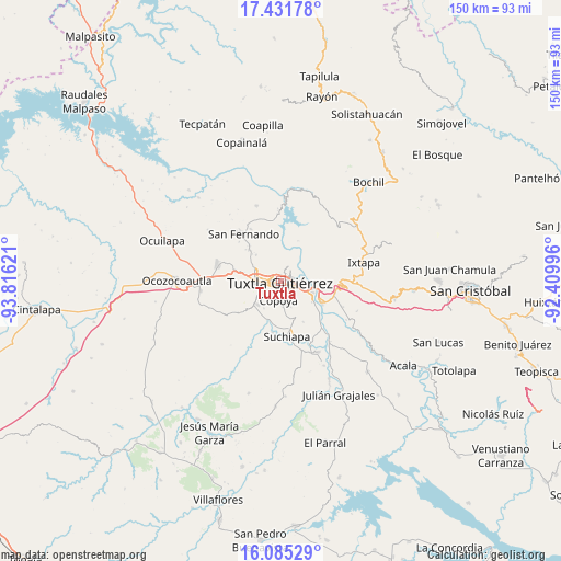
Tuxtla GPS coordinates[2]
16° 45' 35.028" North, 93° 6' 47.088" West
| Map corner | latitude | longitude |
|---|---|---|
| Upper-left | 17.43178°, | -93.81621° |
| Center: | 16.75973°, | -93.11308° |
| Lower-right: | 16.08529°, | -92.40996° |
| Map W x H: | 149.7×149.7 km | = 93×93mi |
| max Lat: | 32.7° ⇑92.2% North |
| Tuxtla: | 16.75973° |
| min Lat: | ⇓7.8% South 14.53588° |
| min Long | Tuxtla | max Long |
| -117.105° | -93.11308° | -86.73105° |
| W 88%⇐ | ⇒12% E |
Elevation
Elevation of Tuxtla is 526 m = 1726 ft, and this is 727.7 m = 2387 ft below average elevation for this country.
| Max E: |
3497 m = 11473 ft | 68.1% |
| Avg. | 1253.7 m = 4113 ft | |
| Tuxtla | 526 m = 1726 ft | |
Min E: |
-1 m = -3 ft | 31.9% |
See also: Tuxtla elevation on elevation.city.
Geographical zone
Tuxtla is located in North Torrid zone (between Equator and Tropic of Cancer). Distance of this Northern Tropic circle is 742.4 km =461.3 mi to North.| Distance of | km | miles | from Tuxtla |
|---|---|---|---|
| North Pole | 8143.6 | 5060.2 | to North |
| Arctic Circle | 5537.7 | 3441 | to North |
| Tropic Cancer | 742.4 | 461.3 | to North |
| Equator | 1863.5 | 1157.9 | to South |


Nearby cities:
15 places around Tuxtla: (largest is in red/bold)
• Chiapa de Corzo
12.2 km =7.6 mi,  118°
118°
• Copoya
5.4 km =3.4 mi,  188°
188°
• Cupasmí
14.8 km =9.2 mi,  130°
130°
• El Jobo
6.3 km =3.9 mi,  172°
172°
• El Palmar (San Gabriel)
14 km =8.7 mi,  47°
47°
• Emiliano Zapata
14.4 km =8.9 mi,  233°
233°
• Jardínes del Grijalva
9 km =5.6 mi,  112°
112°
• Juan del Grijalva
14.9 km =9.3 mi,  103°
103°
• La Libertad
10.8 km =6.7 mi,  287°
287°
• Las Flechas
11.4 km =7.1 mi, 125°
• Pacú
14 km =8.7 mi, 189°
• Ribera Cupía (La Mesa)
14.4 km =8.9 mi, 134°
• Triunfo Agrarista
11.5 km =7.1 mi,  23°
23°
• Viva Cárdenas
12 km =7.5 mi,  314°
314°
• Álvaro Obregón
12.6 km =7.8 mi,  317°
317°
In other languages:
- In Spanish: Tuxtla Gutiérrez, Tuxtla Gtz, Tuxtla Gtz.
- In France: Tuxtla Gutiérrez
- In German: Tuxtla Gutiérrez
- In Italian: Tuxtla Gutiérrez
- In Russian: Тустла-Гутьеррес
- In Chinese: 图斯特拉古铁雷斯
Sources, notices
• [Note1] Compared only with cities in Mexico existing in our database
• [Src1] Map data: © OpenStreetMap contributors (CC-BY-SA)
• [Src2] Other city data from geonames.org with taken over terms of usage.
• [Src3] Geographical zone / Annual Mean Temperature by Robert A. Rohde @ Wikipedia
