Copoya geodata
Copoya (Chiapas) is a populated place; located in Mexico in America/Mexico_City (GMT-6) time zone. With population of 8,160 people, there are 1164 cities with bigger population in this country. Compared to other cities in Mexico, 92.7% of cities are located further ↑North; 88% of cities are located further ←West and 62.5% of cities have higher elevation than Copoya. Note1


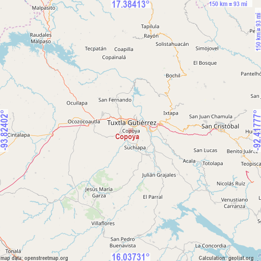
Copoya GPS coordinates[2]
16° 42' 42.876" North, 93° 7' 15.204" West
| Map corner | latitude | longitude |
|---|---|---|
| Upper-left | 17.38413°, | -93.82402° |
| Center: | 16.71191°, | -93.12089° |
| Lower-right: | 16.03731°, | -92.41777° |
| Map W x H: | 149.8×149.8 km | = 93.1×93.1mi |
| max Lat: | 32.7° ⇑92.7% North |
| Copoya: | 16.71191° |
| min Lat: | ⇓7.3% South 14.53588° |
| min Long | Copoya | max Long |
| -117.105° | -93.12089° | -86.73105° |
| W 88%⇐ | ⇒12% E |
Elevation
Elevation of Copoya is 852 m = 2795 ft, and this is 401.7 m = 1318 ft below average elevation for this country.
| Max E: |
3497 m = 11473 ft | 62.5% |
| Avg. | 1253.7 m = 4113 ft | |
| Copoya | 852 m = 2795 ft | |
Min E: |
-1 m = -3 ft | 37.5% |
See also: Mexico elevation on elevation.city.
Geographical zone
Copoya is located in North Torrid zone (between Equator and Tropic of Cancer). Distance of this Northern Tropic circle is 747.7 km =464.6 mi to North.| Distance of | km | miles | from Copoya |
|---|---|---|---|
| North Pole | 8148.9 | 5063.5 | to North |
| Arctic Circle | 5543 | 3444.3 | to North |
| Tropic Cancer | 747.7 | 464.6 | to North |
| Equator | 1858.2 | 1154.6 | to South |


Nearby cities:
15 places around Copoya: (largest is in red/bold)
• Chiapa de Corzo
11.6 km =7.2 mi,  92°
92°
• Cupasmí
12.9 km =8 mi,  109°
109°
• El Jobo
1.9 km =1.2 mi,  119°
119°
• Emiliano Zapata
11.2 km =7 mi,  253°
253°
• Jardínes del Grijalva
9.4 km =5.8 mi,  78°
78°
• La Independencia (Las Pilas)
14.2 km =8.8 mi, 254°
• La Libertad
12.8 km =8 mi,  312°
312°
• Las Flechas
10.1 km =6.3 mi,  97°
97°
• Pacú
8.6 km =5.3 mi,  189°
189°
• Ribera Cupía (La Mesa)
12.1 km =7.5 mi, 113°
• Ribera de Monte Rico (Nacamucuyi)
14.3 km =8.9 mi, 104°
• Salvador Urbina
15.2 km =9.4 mi, 124°
• Suchiapa
9.8 km =6.1 mi,  167°
167°
• Tuxtla
5.4 km =3.4 mi,  8°
8°
• Villahermosa (Reymundo Enríquez)
14.6 km =9.1 mi,  273°
273°
Sources, notices
• [Note1] Compared only with cities in Mexico existing in our database
• [Src1] Map data: © OpenStreetMap contributors (CC-BY-SA)
• [Src2] Other city data from geonames.org with taken over terms of usage.
• [Src3] Geographical zone / Annual Mean Temperature by Robert A. Rohde @ Wikipedia
