Santa Rosa Treinta geodata
Santa Rosa Treinta (Morelos) is a populated place; located in Mexico in America/Mexico_City (GMT-6) time zone. With population of 16,691 people, there are 573 cities with bigger population in this country. Compared to other cities in Mexico, 70.2% of cities are located further ↑North; 52.4% of cities are located further →East and 60.2% of cities have higher elevation than Santa Rosa Treinta. Note1


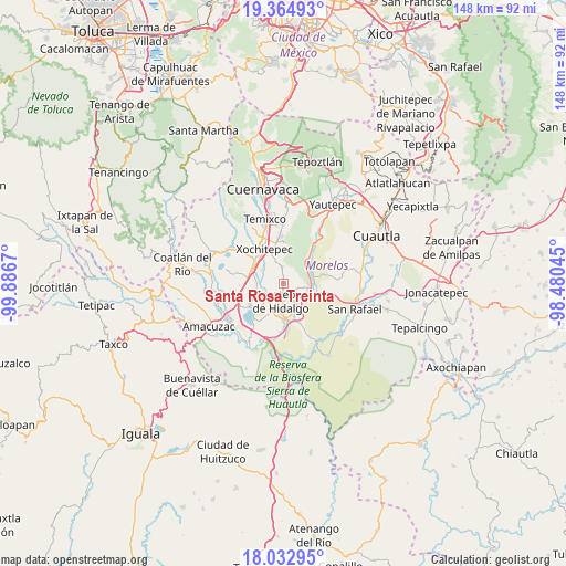
Santa Rosa Treinta GPS coordinates[2]
18° 42' 0.9" North, 99° 11' 0.852" West
| Map corner | latitude | longitude |
|---|---|---|
| Upper-left | 19.36493°, | -99.8867° |
| Center: | 18.70025°, | -99.18357° |
| Lower-right: | 18.03295°, | -98.48045° |
| Map W x H: | 148.1×148.1 km | = 92×92mi |
| max Lat: | 32.7° ⇑70.2% North |
| Santa Rosa Treinta: | 18.70025° |
| min Lat: | ⇓29.8% South 14.53588° |
| min Long | Santa Rosa Trei | max Long |
| -117.105° | -99.18357° | -86.73105° |
| W 47.6%⇐ | ⇒52.4% E |
Elevation
Elevation of Santa Rosa Treinta is 990 m = 3248 ft, and this is 263.7 m = 865 ft below average elevation for this country.
| Max E: |
3497 m = 11473 ft | 60.2% |
| Avg. | 1253.7 m = 4113 ft | |
| Santa Rosa Treinta | 990 m = 3248 ft | |
Min E: |
-1 m = -3 ft | 39.8% |
See also: Mexico elevation on elevation.city.
Geographical zone
Santa Rosa Treinta is located in North Torrid zone (between Equator and Tropic of Cancer). Distance of this Northern Tropic circle is 526.6 km =327.2 mi to North.| Distance of | km | miles | from Santa Rosa Treinta |
|---|---|---|---|
| North Pole | 7927.8 | 4926.1 | to North |
| Arctic Circle | 5321.9 | 3306.9 | to North |
| Tropic Cancer | 526.6 | 327.2 | to North |
| Equator | 2079.3 | 1292 | to South |


Nearby cities:
15 places around Santa Rosa Treinta: (largest is in red/bold)
• Acamilpa
3.3 km =2.1 mi,  56°
56°
• Alfredo V. Bonfil (Chacampalco)
5.9 km =3.7 mi,  148°
148°
• Atlacholoaya
6.5 km =4 mi,  315°
315°
• Bonifacio García
7 km =4.3 mi,  73°
73°
• Colonia Palo Prieto (Chipitongo)
7.5 km =4.7 mi,  86°
86°
• Galeana
7.5 km =4.7 mi,  203°
203°
• Huatecalco
5 km =3.1 mi,  121°
121°
• Pueblo Nuevo
3.2 km =2 mi, 89°
• San Antonio Chiverías
6.7 km =4.2 mi,  216°
216°
• Temimilcingo
4 km =2.5 mi,  36°
36°
• Tetecalita
7.6 km =4.7 mi,  4°
4°
• Tlaltizapán
7 km =4.3 mi,  102°
102°
• Tlaquiltenango
7.6 km =4.7 mi,  163°
163°
• Xoxocotla
6.8 km =4.2 mi,  254°
254°
• Zacatepec
5.2 km =3.2 mi,  187°
187°
Sources, notices
• [Note1] Compared only with cities in Mexico existing in our database
• [Src1] Map data: © OpenStreetMap contributors (CC-BY-SA)
• [Src2] Other city data from geonames.org with taken over terms of usage.
• [Src3] Geographical zone / Annual Mean Temperature by Robert A. Rohde @ Wikipedia
