Xoxocotla geodata
Xoxocotla (Morelos) is a populated place; located in Mexico in America/Mexico_City (GMT-6) time zone. With population of 21,074 people, there are 484 cities with bigger population in this country. Compared to other cities in Mexico, 70.4% of cities are located further ↑North; 53.6% of cities are located further →East and 59.4% of cities have higher elevation than Xoxocotla. Note1


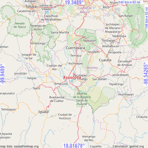
Xoxocotla GPS coordinates[2]
18° 41' 2.94" North, 99° 14' 44.772" West
| Map corner | latitude | longitude |
|---|---|---|
| Upper-left | 19.3489°, | -99.9489° |
| Center: | 18.68415°, | -99.24577° |
| Lower-right: | 18.01678°, | -98.54265° |
| Map W x H: | 148.1×148.1 km | = 92×92mi |
| max Lat: | 32.7° ⇑70.4% North |
| Xoxocotla: | 18.68415° |
| min Lat: | ⇓29.6% South 14.53588° |
| min Long | Xoxocotla | max Long |
| -117.105° | -99.24577° | -86.73105° |
| W 46.4%⇐ | ⇒53.6% E |
Elevation
Elevation of Xoxocotla is 1032 m = 3386 ft, and this is 221.7 m = 727 ft below average elevation for this country.
| Max E: |
3497 m = 11473 ft | 59.4% |
| Avg. | 1253.7 m = 4113 ft | |
| Xoxocotla | 1032 m = 3386 ft | |
Min E: |
-1 m = -3 ft | 40.6% |
See also: Mexico elevation on elevation.city.
Geographical zone
Xoxocotla is located in North Torrid zone (between Equator and Tropic of Cancer). Distance of this Northern Tropic circle is 528.4 km =328.3 mi to North.| Distance of | km | miles | from Xoxocotla |
|---|---|---|---|
| North Pole | 7929.6 | 4927.2 | to North |
| Arctic Circle | 5323.7 | 3308 | to North |
| Tropic Cancer | 528.4 | 328.3 | to North |
| Equator | 2077.5 | 1290.9 | to South |


Nearby cities:
15 places around Xoxocotla: (largest is in red/bold)
• Ahuehuetzingo
6.6 km =4.1 mi,  266°
266°
• Alpuyeca
6.4 km =4 mi,  347°
347°
• Ampliación Nicolás Bravo
7.5 km =4.7 mi,  151°
151°
• Atlacholoaya
6.8 km =4.2 mi,  17°
17°
• Colonia Ampliación 3 de Mayo
6.7 km =4.2 mi,  355°
355°
• Colonia la Pintora
4.2 km =2.6 mi,  343°
343°
• Galeana
6.2 km =3.9 mi, 145°
• Jicarero
8.1 km =5 mi,  163°
163°
• Ninguno [Centro de Readaptación Social de Atlacholoaya]
8.4 km =5.2 mi,  11°
11°
• San Antonio Chiverías
4.4 km =2.7 mi,  144°
144°
• San José Vista Hermosa
3.9 km =2.4 mi,  213°
213°
• Santa Rosa Treinta
6.8 km =4.2 mi,  74°
74°
• Tequesquitengo
8.3 km =5.2 mi,  190°
190°
• Unidad Habitacional José María Morelos y Pavón
7.7 km =4.8 mi, 158°
• Zacatepec
6.8 km =4.2 mi,  119°
119°
Sources, notices
• [Note1] Compared only with cities in Mexico existing in our database
• [Src1] Map data: © OpenStreetMap contributors (CC-BY-SA)
• [Src2] Other city data from geonames.org with taken over terms of usage.
• [Src3] Geographical zone / Annual Mean Temperature by Robert A. Rohde @ Wikipedia
