San Antonio Chiverías geodata
San Antonio Chiverías (Morelos) is a populated place; located in Mexico in America/Mexico_City (GMT-6) time zone. With population of 1,280 people, there are 6771 cities with bigger population in this country. Compared to other cities in Mexico, 70.8% of cities are located further ↑North; 53.1% of cities are located further →East and 60.8% of cities have higher elevation than San Antonio Chiverías. Note1
Current local time in San Antonio Chiverías:
06:46 AM, WednesdayDifference from your time zone: hours


San Antonio Chiverías GPS coordinates[2]
18° 39' 7.992" North, 99° 13' 17.004" West
| Map corner | latitude | longitude |
|---|---|---|
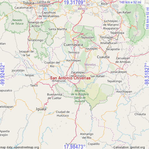
| Upper-left | 19.31709°, | -99.92452° |
| Center: | 18.65222°, | -99.22139° |
| Lower-right: | 17.98473°, | -98.51827° |
| Map W x H: | 148.1×148.1 km | = 92×92mi |
| max Lat: | 32.7° ⇑70.8% North |
| San Antonio Chiverías: | 18.65222° |
| min Lat: | ⇓29.2% South 14.53588° |
| min Long | San Antonio Chi | max Long |
| -117.105° | -99.22139° | -86.73105° |
| W 46.9%⇐ | ⇒53.1% E |
Elevation
Elevation of San Antonio Chiverías is 952 m = 3123 ft, and this is 301.7 m = 990 ft below average elevation for this country.
| Max E: |
3497 m = 11473 ft | 60.8% |
| Avg. | 1253.7 m = 4113 ft | |
| San Antonio Chiverías | 952 m = 3123 ft | |
Min E: |
-1 m = -3 ft | 39.2% |
See also: Mexico elevation on elevation.city.
Geographical zone
San Antonio Chiverías is located in North Torrid zone (between Equator and Tropic of Cancer). Distance of this Northern Tropic circle is 532 km =330.6 mi to North.| Distance of | km | miles | from San Antonio Chiverías |
|---|---|---|---|
| North Pole | 7933.1 | 4929.4 | to North |
| Arctic Circle | 5327.2 | 3310.2 | to North |
| Tropic Cancer | 532 | 330.6 | to North |
| Equator | 2073.9 | 1288.7 | to South |


Nearby cities:
15 places around San Antonio Chiverías: (largest is in red/bold)
• Alfredo V. Bonfil (Chacampalco)
7.1 km =4.4 mi,  87°
87°
• Ampliación Nicolás Bravo
3.2 km =2 mi,  161°
161°
• Colonia 3 de Mayo (El Tepiolol)
7.6 km =4.7 mi,  105°
105°
• Galeana
1.8 km =1.1 mi,  148°
148°
• Jicarero
4.2 km =2.6 mi,  182°
182°
• Jojutla
6 km =3.7 mi,  133°
133°
• Pedro Amaro
8 km =5 mi,  140°
140°
• San José Vista Hermosa
4.7 km =2.9 mi,  272°
272°
• Santa Rosa Treinta
6.7 km =4.2 mi,  36°
36°
• Tequesquitengo
6.1 km =3.8 mi,  221°
221°
• Tlaquiltenango
6.4 km =4 mi, 108°
• Tlatenchi
7.2 km =4.5 mi, 149°
• Unidad Habitacional José María Morelos y Pavón
3.6 km =2.2 mi, 175°
• Xoxocotla
4.4 km =2.7 mi,  324°
324°
• Zacatepec
3.3 km =2.1 mi, 86°
Sources, notices
• [Note1] Compared only with cities in Mexico existing in our database
• [Src1] Map data: © OpenStreetMap contributors (CC-BY-SA)
• [Src2] Other city data from geonames.org with taken over terms of usage.
• [Src3] Geographical zone / Annual Mean Temperature by Robert A. Rohde @ Wikipedia
