Atlacholoaya geodata
Atlacholoaya (Morelos) is a populated place; located in Mexico in America/Mexico_City (GMT-6) time zone. With population of 4,131 people, there are 2216 cities with bigger population in this country. Compared to other cities in Mexico, 69.7% of cities are located further ↑North; 53.2% of cities are located further →East and 58.4% of cities have higher elevation than Atlacholoaya. Note1


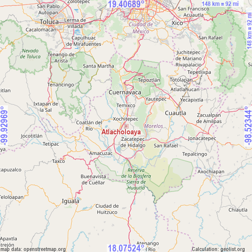
Atlacholoaya GPS coordinates[2]
18° 44' 32.568" North, 99° 13' 35.616" West
| Map corner | latitude | longitude |
|---|---|---|
| Upper-left | 19.40689°, | -99.92969° |
| Center: | 18.74238°, | -99.22656° |
| Lower-right: | 18.07524°, | -98.52344° |
| Map W x H: | 148.1×148.1 km | = 92×92mi |
| max Lat: | 32.7° ⇑69.7% North |
| Atlacholoaya: | 18.74238° |
| min Lat: | ⇓30.3% South 14.53588° |
| min Long | Atlacholoaya | max Long |
| -117.105° | -99.22656° | -86.73105° |
| W 46.8%⇐ | ⇒53.2% E |
Elevation
Elevation of Atlacholoaya is 1087 m = 3566 ft, and this is 166.7 m = 547 ft below average elevation for this country.
| Max E: |
3497 m = 11473 ft | 58.4% |
| Avg. | 1253.7 m = 4113 ft | |
| Atlacholoaya | 1087 m = 3566 ft | |
Min E: |
-1 m = -3 ft | 41.6% |
See also: Mexico elevation on elevation.city.
Geographical zone
Atlacholoaya is located in North Torrid zone (between Equator and Tropic of Cancer). Distance of this Northern Tropic circle is 522 km =324.4 mi to North.| Distance of | km | miles | from Atlacholoaya |
|---|---|---|---|
| North Pole | 7923.1 | 4923.2 | to North |
| Arctic Circle | 5317.2 | 3304 | to North |
| Tropic Cancer | 522 | 324.4 | to North |
| Equator | 2084 | 1294.9 | to South |


Nearby cities:
15 places around Atlacholoaya: (largest is in red/bold)
• Acamilpa
7.8 km =4.8 mi,  111°
111°
• Alpuyeca
3.5 km =2.2 mi,  265°
265°
• Chiconcuac
4.9 km =3 mi,  24°
24°
• Colonia Ampliación 3 de Mayo
2.6 km =1.6 mi, 273°
• Colonia la Pintora
4 km =2.5 mi,  233°
233°
• Francisco Villa
5.4 km =3.4 mi,  338°
338°
• La Esperanza
7.4 km =4.6 mi,  356°
356°
• Ninguno [Centro de Readaptación Social de Atlacholoaya]
1.7 km =1.1 mi,  349°
349°
• Santa Rosa Treinta
6.5 km =4 mi,  135°
135°
• Temimilcingo
7.1 km =4.4 mi,  101°
101°
• Tepetzingo
7 km =4.3 mi,  47°
47°
• Tetecalita
5.9 km =3.7 mi,  60°
60°
• Tezoyuca
7.4 km =4.6 mi, 20°
• Xochitepec
4.3 km =2.7 mi, 354°
• Xoxocotla
6.8 km =4.2 mi,  197°
197°
Sources, notices
• [Note1] Compared only with cities in Mexico existing in our database
• [Src1] Map data: © OpenStreetMap contributors (CC-BY-SA)
• [Src2] Other city data from geonames.org with taken over terms of usage.
• [Src3] Geographical zone / Annual Mean Temperature by Robert A. Rohde @ Wikipedia
