Toluca geodata
Toluca (Chiapas) is a populated place; located in Mexico in America/Mexico_City (GMT-6) time zone. With population of 865 people, there are 10114 cities with bigger population in this country. Compared to other cities in Mexico, 99.4% of cities are located further ↑North; 93.8% of cities are located further ←West and 68.2% of cities have higher elevation than Toluca. Note1


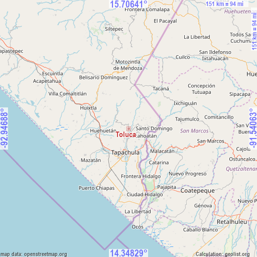
Toluca GPS coordinates[2]
15° 1' 42.348" North, 92° 14' 37.5" West
| Map corner | latitude | longitude |
|---|---|---|
| Upper-left | 15.70641°, | -92.94688° |
| Center: | 15.02843°, | -92.24375° |
| Lower-right: | 14.34829°, | -91.54063° |
| Map W x H: | 151×151 km | = 93.8×93.8mi |
| max Lat: | 32.7° ⇑99.4% North |
| Toluca: | 15.02843° |
| min Lat: | ⇓0.6% South 14.53588° |
| min Long | Toluca | max Long |
| -117.105° | -92.24375° | -86.73105° |
| W 93.8%⇐ | ⇒6.2% E |
Elevation
Elevation of Toluca is 521 m = 1709 ft, and this is 732.7 m = 2404 ft below average elevation for this country.
| Max E: |
3497 m = 11473 ft | 68.2% |
| Avg. | 1253.7 m = 4113 ft | |
| Toluca | 521 m = 1709 ft | |
Min E: |
-1 m = -3 ft | 31.8% |
See also: Mexico elevation on elevation.city.
Geographical zone
Toluca is located in North Torrid zone (between Equator and Tropic of Cancer). Distance of this Northern Tropic circle is 934.9 km =580.9 mi to North.| Distance of | km | miles | from Toluca |
|---|---|---|---|
| North Pole | 8336.1 | 5179.8 | to North |
| Arctic Circle | 5730.2 | 3560.6 | to North |
| Tropic Cancer | 934.9 | 580.9 | to North |
| Equator | 1671 | 1038.3 | to South |


Nearby cities:
15 places around Toluca: (largest is in red/bold)
• 26 de Octubre
6.3 km =3.9 mi,  351°
351°
• Benito Juárez
6.4 km =4 mi,  62°
62°
• Carrillo Puerto
5.5 km =3.4 mi,  110°
110°
• El Chaparrón
5.6 km =3.5 mi,  181°
181°
• El Triunfo
4.8 km =3 mi,  150°
150°
• Fracción Galeras
3.2 km =2 mi,  26°
26°
• Fracción las Palmas
2.1 km =1.3 mi, 29°
• Hermosillo
6.3 km =3.9 mi,  127°
127°
• Independencia
5.5 km =3.4 mi,  306°
306°
• Los Ángeles
3.6 km =2.2 mi,  103°
103°
• Nueva Granada
6.6 km =4.1 mi,  220°
220°
• Salvador Urbina
3.9 km =2.4 mi,  78°
78°
• San Agustín Jitotol
4.6 km =2.9 mi,  139°
139°
• Unión Roja
3.6 km =2.2 mi, 55°
• Veinte de Noviembre
6.1 km =3.8 mi,  201°
201°
Sources, notices
• [Note1] Compared only with cities in Mexico existing in our database
• [Src1] Map data: © OpenStreetMap contributors (CC-BY-SA)
• [Src2] Other city data from geonames.org with taken over terms of usage.
• [Src3] Geographical zone / Annual Mean Temperature by Robert A. Rohde @ Wikipedia
