26 de Octubre geodata
26 de Octubre (Chiapas) is a populated place; located in Mexico in America/Mexico_City (GMT-6) time zone. With population of 986 people, there are 8824 cities with bigger population in this country. Compared to other cities in Mexico, 99.2% of cities are located further ↑North; 93.8% of cities are located further ←West and 62.9% of cities have higher elevation than 26 de Octubre. Note1


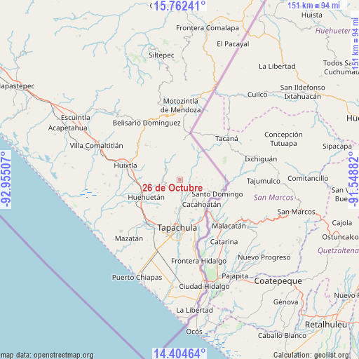
26 de Octubre GPS coordinates[2]
15° 5' 4.596" North, 92° 15' 6.984" West
| Map corner | latitude | longitude |
|---|---|---|
| Upper-left | 15.76241°, | -92.95507° |
| Center: | 15.08461°, | -92.25194° |
| Lower-right: | 14.40464°, | -91.54882° |
| Map W x H: | 151×151 km | = 93.8×93.8mi |
| max Lat: | 32.7° ⇑99.2% North |
| 26 de Octubre: | 15.08461° |
| min Lat: | ⇓0.8% South 14.53588° |
| min Long | 26 de Octubre | max Long |
| -117.105° | -92.25194° | -86.73105° |
| W 93.8%⇐ | ⇒6.2% E |
Elevation
Elevation of 26 de Octubre is 823 m = 2700 ft, and this is 430.7 m = 1413 ft below average elevation for this country.
| Max E: |
3497 m = 11473 ft | 62.9% |
| Avg. | 1253.7 m = 4113 ft | |
| 26 de Octubre | 823 m = 2700 ft | |
Min E: |
-1 m = -3 ft | 37.1% |
See also: Mexico elevation on elevation.city.
Geographical zone
26 de Octubre is located in North Torrid zone (between Equator and Tropic of Cancer). Distance of this Northern Tropic circle is 928.7 km =577.1 mi to North.| Distance of | km | miles | from 26 de Octubre |
|---|---|---|---|
| North Pole | 8329.8 | 5175.9 | to North |
| Arctic Circle | 5723.9 | 3556.7 | to North |
| Tropic Cancer | 928.7 | 577.1 | to North |
| Equator | 1677.3 | 1042.2 | to South |


Nearby cities:
15 places around 26 de Octubre: (largest is in red/bold)
• Agustín de Iturbide
5.8 km =3.6 mi,  100°
100°
• Benito Juárez
7.3 km =4.5 mi,  116°
116°
• El Edén
5.8 km =3.6 mi,  242°
242°
• El Manacal
4.2 km =2.6 mi,  60°
60°
• El Progreso
5.8 km =3.6 mi,  87°
87°
• El Águila
7.2 km =4.5 mi,  82°
82°
• Fracción Galeras
4.1 km =2.5 mi,  146°
146°
• Fracción las Palmas
4.8 km =3 mi,  156°
156°
• Independencia
4.6 km =2.9 mi,  230°
230°
• Nuevo Chespal
5.6 km =3.5 mi,  52°
52°
• Salvador Urbina
7.2 km =4.5 mi,  139°
139°
• San Antonio Chicharras
1.2 km =0.7 mi, 57°
• Toluca
6.3 km =3.9 mi,  171°
171°
• Unión Roja
5.7 km =3.5 mi, 138°
• Zaragoza
7.7 km =4.8 mi,  311°
311°
Sources, notices
• [Note1] Compared only with cities in Mexico existing in our database
• [Src1] Map data: © OpenStreetMap contributors (CC-BY-SA)
• [Src2] Other city data from geonames.org with taken over terms of usage.
• [Src3] Geographical zone / Annual Mean Temperature by Robert A. Rohde @ Wikipedia
