Tlamanca geodata
Tlamanca (Puebla) is a populated place; located in Mexico in America/Mexico_City (GMT-6) time zone. With population of 1,226 people, there are 7077 cities with bigger population in this country. Compared to other cities in Mexico, 50.3% of cities are located further ↑North; 67.3% of cities are located further ←West and 73.4% of cities have lower elevation than Tlamanca. Note1


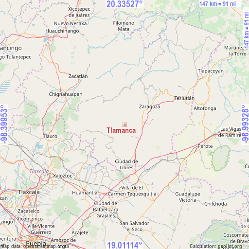
Tlamanca GPS coordinates[2]
19° 40' 28.452" North, 97° 41' 47.04" West
| Map corner | latitude | longitude |
|---|---|---|
| Upper-left | 20.33527°, | -98.39953° |
| Center: | 19.67457°, | -97.6964° |
| Lower-right: | 19.01114°, | -96.99328° |
| Map W x H: | 147.2×147.2 km | = 91.5×91.5mi |
| max Lat: | 32.7° ⇑50.3% North |
| Tlamanca: | 19.67457° |
| min Lat: | ⇓49.7% South 14.53588° |
| min Long | Tlamanca | max Long |
| -117.105° | -97.6964° | -86.73105° |
| W 67.3%⇐ | ⇒32.7% E |
Elevation
Elevation of Tlamanca is 1999 m = 6558 ft, and this is 745.3 m = 2445 ft above average elevation for this country.
| Max E: |
3497 m = 11473 ft | 26.6% |
| Tlamanca | 1999 m 6558 ft | |
| Avg. | 1253.7 m = 4113 ft | |
Min E: |
-1 m = -3 ft | 73.4% |
See also: Mexico elevation on elevation.city.
Geographical zone
Tlamanca is located in North Torrid zone (between Equator and Tropic of Cancer). Distance of this Northern Tropic circle is 418.3 km =259.9 mi to North.| Distance of | km | miles | from Tlamanca |
|---|---|---|---|
| North Pole | 7819.5 | 4858.8 | to North |
| Arctic Circle | 5213.6 | 3239.6 | to North |
| Tropic Cancer | 418.3 | 259.9 | to North |
| Equator | 2187.6 | 1359.3 | to South |


Nearby cities:
15 places around Tlamanca: (largest is in red/bold)
• Chilapa
11 km =6.8 mi,  23°
23°
• Contla
1.9 km =1.2 mi,  247°
247°
• Cuyoaco
11.4 km =7.1 mi,  135°
135°
• Emilio Carranza (Santa Cruz)
6.2 km =3.9 mi,  47°
47°
• Huitzitzilapan
12.5 km =7.8 mi,  75°
75°
• La Libertad
13 km =8.1 mi, 45°
• La Unión Ejido Mexcaltepec
7.5 km =4.7 mi,  191°
191°
• San Andrés Yahuitlalpan
3.2 km =2 mi,  267°
267°
• San Francisco del Progreso
11.1 km =6.9 mi,  56°
56°
• San Miguel Tenextatiloyan
11 km =6.8 mi,  69°
69°
• Tateno
7.9 km =4.9 mi,  198°
198°
• Temextla
7.9 km =4.9 mi,  157°
157°
• Tentzoncuahuigtic
10.7 km =6.6 mi,  275°
275°
• Tepexoxuca
10.7 km =6.6 mi,  213°
213°
• Zautla
5.2 km =3.2 mi,  30°
30°
Sources, notices
• [Note1] Compared only with cities in Mexico existing in our database
• [Src1] Map data: © OpenStreetMap contributors (CC-BY-SA)
• [Src2] Other city data from geonames.org with taken over terms of usage.
• [Src3] Geographical zone / Annual Mean Temperature by Robert A. Rohde @ Wikipedia
