Tlacotalpan geodata
Tlacotalpan (Veracruz) is a seat of a second-order administrative division; located in Mexico in America/Mexico_City (GMT-6) time zone. With population of 7,600 people, there are 1224 cities with bigger population in this country. Compared to other cities in Mexico, 71.3% of cities are located further ↑North; 83% of cities are located further ←West and 97.5% of cities have higher elevation than Tlacotalpan. Note1


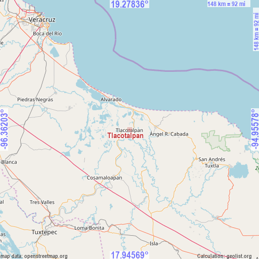
Tlacotalpan GPS coordinates[2]
18° 36' 47.988" North, 95° 39' 32.04" West
| Map corner | latitude | longitude |
|---|---|---|
| Upper-left | 19.27836°, | -96.36203° |
| Center: | 18.61333°, | -95.6589° |
| Lower-right: | 17.94569°, | -94.95578° |
| Map W x H: | 148.2×148.2 km | = 92.1×92.1mi |
| max Lat: | 32.7° ⇑71.3% North |
| Tlacotalpan: | 18.61333° |
| min Lat: | ⇓28.7% South 14.53588° |
| min Long | Tlacotalpan | max Long |
| -117.105° | -95.6589° | -86.73105° |
| W 83%⇐ | ⇒17% E |
Elevation
Elevation of Tlacotalpan is 9 m = 30 ft, and this is 1244.7 m = 4084 ft below average elevation for this country.
| Max E: |
3497 m = 11473 ft | 97.5% |
| Avg. | 1253.7 m = 4113 ft | |
| Tlacotalpan | 9 m = 30 ft | |
Min E: |
-1 m = -3 ft | 2.5% |
See also: Mexico elevation on elevation.city.
Geographical zone
Tlacotalpan is located in North Torrid zone (between Equator and Tropic of Cancer). Distance of this Northern Tropic circle is 536.3 km =333.2 mi to North.| Distance of | km | miles | from Tlacotalpan |
|---|---|---|---|
| North Pole | 7937.5 | 4932.1 | to North |
| Arctic Circle | 5331.6 | 3312.9 | to North |
| Tropic Cancer | 536.3 | 333.2 | to North |
| Equator | 2069.6 | 1286 | to South |


Nearby cities:
15 places around Tlacotalpan: (largest is in red/bold)
• Acula
17.1 km =10.6 mi,  225°
225°
• Alvarado
20.7 km =12.9 mi,  328°
328°
• Amatitlán
21.7 km =13.5 mi,  201°
201°
• Dos Bocas
23.1 km =14.4 mi,  192°
192°
• El Corte
19.6 km =12.2 mi, 204°
• El Escobillal
24.9 km =15.5 mi,  98°
98°
• La Providencia
22.6 km =14 mi,  119°
119°
• Lerdo de Tejada
14.8 km =9.2 mi,  83°
83°
• Paso Nacional
19.5 km =12.1 mi, 330°
• Saltabarranca
13.6 km =8.5 mi, 100°
• San Juan de los Reyes (Luis Valenzuela)
24.6 km =15.3 mi, 115°
• Santa Teresa
17.6 km =10.9 mi,  88°
88°
• Santiago
25.7 km =16 mi,  224°
224°
• Zamora
18.8 km =11.7 mi, 101°
• Ángel R. Cabada
22.5 km =14 mi, 94°
Sources, notices
• [Note1] Compared only with cities in Mexico existing in our database
• [Src1] Map data: © OpenStreetMap contributors (CC-BY-SA)
• [Src2] Other city data from geonames.org with taken over terms of usage.
• [Src3] Geographical zone / Annual Mean Temperature by Robert A. Rohde @ Wikipedia
