Acula geodata
Acula (Veracruz) is a seat of a second-order administrative division; located in Mexico in America/Mexico_City (GMT-6) time zone. With population of 2,639 people, there are 3345 cities with bigger population in this country. Compared to other cities in Mexico, 72.5% of cities are located further ↑North; 82.7% of cities are located further ←West and 97.5% of cities have higher elevation than Acula. Note1


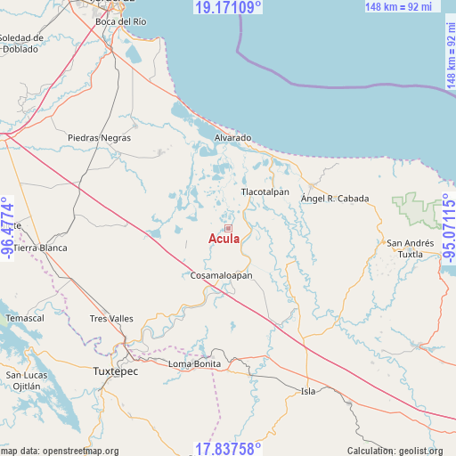
Acula GPS coordinates[2]
18° 30' 20.268" North, 95° 46' 27.372" West
| Map corner | latitude | longitude |
|---|---|---|
| Upper-left | 19.17109°, | -96.4774° |
| Center: | 18.50563°, | -95.77427° |
| Lower-right: | 17.83758°, | -95.07115° |
| Map W x H: | 148.3×148.3 km | = 92.1×92.1mi |
| max Lat: | 32.7° ⇑72.5% North |
| Acula: | 18.50563° |
| min Lat: | ⇓27.5% South 14.53588° |
| min Long | Acula | max Long |
| -117.105° | -95.77427° | -86.73105° |
| W 82.7%⇐ | ⇒17.3% E |
Elevation
Elevation of Acula is 9 m = 30 ft, and this is 1244.7 m = 4084 ft below average elevation for this country.
| Max E: |
3497 m = 11473 ft | 97.5% |
| Avg. | 1253.7 m = 4113 ft | |
| Acula | 9 m = 30 ft | |
Min E: |
-1 m = -3 ft | 2.5% |
See also: Mexico elevation on elevation.city.
Geographical zone
Acula is located in North Torrid zone (between Equator and Tropic of Cancer). Distance of this Northern Tropic circle is 548.3 km =340.7 mi to North.| Distance of | km | miles | from Acula |
|---|---|---|---|
| North Pole | 7949.4 | 4939.5 | to North |
| Arctic Circle | 5343.5 | 3320.3 | to North |
| Tropic Cancer | 548.3 | 340.7 | to North |
| Equator | 2057.6 | 1278.5 | to South |


Nearby cities:
15 places around Acula: (largest is in red/bold)
• Amatitlán
9.3 km =5.8 mi,  152°
152°
• Arroyo del Soldado (Arroyo del Obispo)
21.1 km =13.1 mi,  181°
181°
• Carlos A. Carrillo
14.7 km =9.1 mi,  171°
171°
• Chicalpextle
14.2 km =8.8 mi,  205°
205°
• Cosamaloapan
15.6 km =9.7 mi,  189°
189°
• Dos Bocas
12.7 km =7.9 mi, 146°
• El Corte
7.2 km =4.5 mi, 145°
• El Mirador
19.8 km =12.3 mi,  220°
220°
• Mozapa
13.9 km =8.6 mi, 213°
• Pachuca
13 km =8.1 mi, 217°
• San Francisco (Oyozontle)
21 km =13 mi,  201°
201°
• Santiago
8.7 km =5.4 mi, 223°
• Tilapa
21.4 km =13.3 mi, 175°
• Tlacotalpan
17.1 km =10.6 mi,  45°
45°
• Venustiano Carranza
14.3 km =8.9 mi,  156°
156°
Sources, notices
• [Note1] Compared only with cities in Mexico existing in our database
• [Src1] Map data: © OpenStreetMap contributors (CC-BY-SA)
• [Src2] Other city data from geonames.org with taken over terms of usage.
• [Src3] Geographical zone / Annual Mean Temperature by Robert A. Rohde @ Wikipedia
