Guadalupe Libertad geodata
Guadalupe Libertad (Puebla) is a populated place; located in Mexico in America/Mexico_City (GMT-6) time zone. With population of 1,476 people, there are 5851 cities with bigger population in this country. Compared to other cities in Mexico, 61.4% of cities are located further ↑North; 70.7% of cities are located further ←West and 92.8% of cities have lower elevation than Guadalupe Libertad. Note1


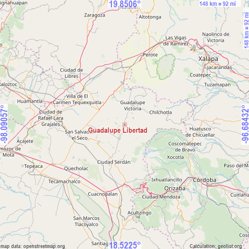
Guadalupe Libertad GPS coordinates[2]
19° 11' 16.404" North, 97° 23' 14.784" West
| Map corner | latitude | longitude |
|---|---|---|
| Upper-left | 19.8506°, | -98.09057° |
| Center: | 19.18789°, | -97.38744° |
| Lower-right: | 18.5225°, | -96.68432° |
| Map W x H: | 147.7×147.7 km | = 91.8×91.8mi |
| max Lat: | 32.7° ⇑61.4% North |
| Guadalupe Libertad: | 19.18789° |
| min Lat: | ⇓38.6% South 14.53588° |
| min Long | Guadalupe Liber | max Long |
| -117.105° | -97.38744° | -86.73105° |
| W 70.7%⇐ | ⇒29.3% E |
Elevation
Elevation of Guadalupe Libertad is 2518 m = 8261 ft, and this is 1264.3 m = 4148 ft above average elevation for this country.
| Max E: |
3497 m = 11473 ft | 7.2% |
| Guadalupe Libertad | 2518 m 8261 ft | |
| Avg. | 1253.7 m = 4113 ft | |
Min E: |
-1 m = -3 ft | 92.8% |
See also: Mexico elevation on elevation.city.
Geographical zone
Guadalupe Libertad is located in North Torrid zone (between Equator and Tropic of Cancer). Distance of this Northern Tropic circle is 472.4 km =293.5 mi to North.| Distance of | km | miles | from Guadalupe Libertad |
|---|---|---|---|
| North Pole | 7873.6 | 4892.4 | to North |
| Arctic Circle | 5267.7 | 3273.2 | to North |
| Tropic Cancer | 472.4 | 293.5 | to North |
| Equator | 2133.5 | 1325.7 | to South |


Nearby cities:
15 places around Guadalupe Libertad: (largest is in red/bold)
• Cuauhtémoc
6.5 km =4 mi,  52°
52°
• Emancipación Quetzalapa
1.7 km =1.1 mi,  196°
196°
• Francisco I. Madero (El Sabinal)
8.1 km =5 mi,  33°
33°
• José María Morelos
9.9 km =6.2 mi,  238°
238°
• Lázaro Cárdenas
5.2 km =3.2 mi, 195°
• Oyamecalco el Cajón
11 km =6.8 mi,  137°
137°
• Paso Nacional
5.8 km =3.6 mi,  147°
147°
• Rafael Avila Camacho
7.4 km =4.6 mi, 201°
• San José la Capilla
4.1 km =2.5 mi,  12°
12°
• San Miguel Zoapan
12.1 km =7.5 mi,  162°
162°
• Santa Cecilia Tepetitlán
4.9 km =3 mi,  276°
276°
• Santa Inés Varela la Luz
3.7 km =2.3 mi,  182°
182°
• Tlachichuca
8.8 km =5.5 mi, 202°
• Venustiano Carranza
10.4 km =6.5 mi,  294°
294°
• Álamos Tepetitlán
5.4 km =3.4 mi, 279°
Sources, notices
• [Note1] Compared only with cities in Mexico existing in our database
• [Src1] Map data: © OpenStreetMap contributors (CC-BY-SA)
• [Src2] Other city data from geonames.org with taken over terms of usage.
• [Src3] Geographical zone / Annual Mean Temperature by Robert A. Rohde @ Wikipedia
