Santa Inés Varela la Luz geodata
Santa Inés Varela la Luz (Puebla) is a populated place; located in Mexico in America/Mexico_City (GMT-6) time zone. With population of 1,075 people, there are 8116 cities with bigger population in this country. Compared to other cities in Mexico, 62.1% of cities are located further ↑North; 70.7% of cities are located further ←West and 95.8% of cities have lower elevation than Santa Inés Varela la Luz. Note1
Current local time in Santa Inés Varela la Luz:
08:59 AM, MondayDifference from your time zone: hours


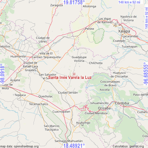
Santa Inés Varela la Luz GPS coordinates[2]
19° 9' 17.028" North, 97° 23' 19.212" West
| Map corner | latitude | longitude |
|---|---|---|
| Upper-left | 19.81758°, | -98.0918° |
| Center: | 19.15473°, | -97.38867° |
| Lower-right: | 18.48921°, | -96.68555° |
| Map W x H: | 147.7×147.7 km | = 91.8×91.8mi |
| max Lat: | 32.7° ⇑62.1% North |
| Santa Inés Varela la Luz: | 19.15473° |
| min Lat: | ⇓37.9% South 14.53588° |
| min Long | Santa Inés Var | max Long |
| -117.105° | -97.38867° | -86.73105° |
| W 70.7%⇐ | ⇒29.3% E |
Elevation
Elevation of Santa Inés Varela la Luz is 2618 m = 8589 ft, and this is 1364.3 m = 4476 ft above average elevation for this country.
| Max E: |
3497 m = 11473 ft | 4.2% |
| Santa Inés Varela la Luz | 2618 m 8589 ft | |
| Avg. | 1253.7 m = 4113 ft | |
Min E: |
-1 m = -3 ft | 95.8% |
See also: Mexico elevation on elevation.city.
Geographical zone
Santa Inés Varela la Luz is located in North Torrid zone (between Equator and Tropic of Cancer). Distance of this Northern Tropic circle is 476.1 km =295.8 mi to North.| Distance of | km | miles | from Santa Inés Varela la Luz |
|---|---|---|---|
| North Pole | 7877.3 | 4894.7 | to North |
| Arctic Circle | 5271.4 | 3275.5 | to North |
| Tropic Cancer | 476.1 | 295.8 | to North |
| Equator | 2129.8 | 1323.4 | to South |


Nearby cities:
15 places around Santa Inés Varela la Luz: (largest is in red/bold)
• Cuauhtémoc
9.3 km =5.8 mi,  34°
34°
• Emancipación Quetzalapa
2.1 km =1.3 mi,  350°
350°
• Guadalupe Libertad
3.7 km =2.3 mi,  2°
2°
• José María Morelos
8.5 km =5.3 mi,  259°
259°
• Lázaro Cárdenas
1.8 km =1.1 mi,  223°
223°
• Manuel Edgardo Ávalos (San Isidro)
9.7 km =6 mi,  182°
182°
• Oyamecalco el Cajón
8.8 km =5.5 mi,  120°
120°
• Paso Nacional
3.5 km =2.2 mi,  110°
110°
• Rafael Avila Camacho
4.1 km =2.5 mi, 218°
• San José la Capilla
7.8 km =4.8 mi,  7°
7°
• San Miguel Zoapan
8.7 km =5.4 mi,  154°
154°
• Santa Cecilia Tepetitlán
6.3 km =3.9 mi,  311°
311°
• Santa María el Aserradero (Peones Acasillados)
9.3 km =5.8 mi, 177°
• Tlachichuca
5.5 km =3.4 mi, 215°
• Álamos Tepetitlán
7 km =4.3 mi, 311°
Sources, notices
• [Note1] Compared only with cities in Mexico existing in our database
• [Src1] Map data: © OpenStreetMap contributors (CC-BY-SA)
• [Src2] Other city data from geonames.org with taken over terms of usage.
• [Src3] Geographical zone / Annual Mean Temperature by Robert A. Rohde @ Wikipedia
