San Miguel Zoapan geodata
San Miguel Zoapan (Puebla) is a populated place; located in Mexico in America/Mexico_City (GMT-6) time zone. With population of 1,077 people, there are 8093 cities with bigger population in this country. Compared to other cities in Mexico, 63.3% of cities are located further ↑North; 71% of cities are located further ←West and 99.8% of cities have lower elevation than San Miguel Zoapan. Note1


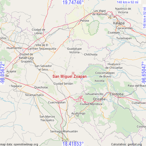
San Miguel Zoapan GPS coordinates[2]
19° 5' 3.588" North, 97° 21' 12.924" West
| Map corner | latitude | longitude |
|---|---|---|
| Upper-left | 19.74746°, | -98.05672° |
| Center: | 19.08433°, | -97.35359° |
| Lower-right: | 18.41853°, | -96.65047° |
| Map W x H: | 147.8×147.8 km | = 91.8×91.8mi |
| max Lat: | 32.7° ⇑63.3% North |
| San Miguel Zoapan: | 19.08433° |
| min Lat: | ⇓36.7% South 14.53588° |
| min Long | San Miguel Zoap | max Long |
| -117.105° | -97.35359° | -86.73105° |
| W 71%⇐ | ⇒29% E |
Elevation
Elevation of San Miguel Zoapan is 3003 m = 9852 ft, and this is 1749.3 m = 5739 ft above average elevation for this country.
| Max E: |
3497 m = 11473 ft | 0.2% |
| San Miguel Zoapan | 3003 m 9852 ft | |
| Avg. | 1253.7 m = 4113 ft | |
Min E: |
-1 m = -3 ft | 99.8% |
See also: Mexico elevation on elevation.city.
Geographical zone
San Miguel Zoapan is located in North Torrid zone (between Equator and Tropic of Cancer). Distance of this Northern Tropic circle is 483.9 km =300.7 mi to North.| Distance of | km | miles | from San Miguel Zoapan |
|---|---|---|---|
| North Pole | 7885.1 | 4899.6 | to North |
| Arctic Circle | 5279.2 | 3280.3 | to North |
| Tropic Cancer | 483.9 | 300.7 | to North |
| Equator | 2122 | 1318.5 | to South |


Nearby cities:
15 places around San Miguel Zoapan: (largest is in red/bold)
• Ahuatepec de Camino
9.8 km =6.1 mi,  240°
240°
• Emancipación Quetzalapa
10.7 km =6.6 mi,  337°
337°
• Lázaro Cárdenas
8.2 km =5.1 mi,  322°
322°
• Manuel Edgardo Ávalos (San Isidro)
4.4 km =2.7 mi,  245°
245°
• Oyamecalco el Cajón
5.1 km =3.2 mi,  48°
48°
• Paso Nacional
6.6 km =4.1 mi,  356°
356°
• Rafael Avila Camacho
7.8 km =4.8 mi,  306°
306°
• San Francisco Independencia (Santa María Aserradero)
8.2 km =5.1 mi,  257°
257°
• San Isidro Canoas Altas
11.3 km =7 mi,  179°
179°
• San José Llano Grande
3.6 km =2.2 mi, 180°
• San Martín Ojo de Agua
9 km =5.6 mi,  206°
206°
• San Miguel Ocotenco
10.6 km =6.6 mi, 259°
• Santa Inés Varela la Luz
8.7 km =5.4 mi,  334°
334°
• Santa María el Aserradero (Peones Acasillados)
3.5 km =2.2 mi, 245°
• Tlachichuca
7.7 km =4.8 mi,  296°
296°
Sources, notices
• [Note1] Compared only with cities in Mexico existing in our database
• [Src1] Map data: © OpenStreetMap contributors (CC-BY-SA)
• [Src2] Other city data from geonames.org with taken over terms of usage.
• [Src3] Geographical zone / Annual Mean Temperature by Robert A. Rohde @ Wikipedia
