Tilapa geodata
Tilapa (Puebla) is a seat of a second-order administrative division; located in Mexico in America/Mexico_City (GMT-6) time zone. With population of 2,759 people, there are 3207 cities with bigger population in this country. Compared to other cities in Mexico, 71.5% of cities are located further ↑North; 56.6% of cities are located further ←West and 54.1% of cities have higher elevation than Tilapa. Note1


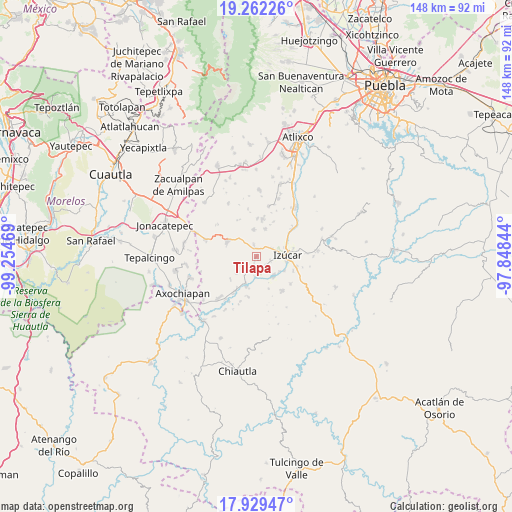
Tilapa GPS coordinates[2]
18° 35' 49.812" North, 98° 33' 5.616" West
| Map corner | latitude | longitude |
|---|---|---|
| Upper-left | 19.26226°, | -99.25469° |
| Center: | 18.59717°, | -98.55156° |
| Lower-right: | 17.92947°, | -97.84844° |
| Map W x H: | 148.2×148.2 km | = 92.1×92.1mi |
| max Lat: | 32.7° ⇑71.5% North |
| Tilapa: | 18.59717° |
| min Lat: | ⇓28.5% South 14.53588° |
| min Long | Tilapa | max Long |
| -117.105° | -98.55156° | -86.73105° |
| W 56.6%⇐ | ⇒43.4% E |
Elevation
Elevation of Tilapa is 1238 m = 4062 ft, and this is 15.7 m = 52 ft below average elevation for this country.
| Max E: |
3497 m = 11473 ft | 54.1% |
| Avg. | 1253.7 m = 4113 ft | |
| Tilapa | 1238 m = 4062 ft | |
Min E: |
-1 m = -3 ft | 45.9% |
See also: Mexico elevation on elevation.city.
Geographical zone
Tilapa is located in North Torrid zone (between Equator and Tropic of Cancer). Distance of this Northern Tropic circle is 538.1 km =334.4 mi to North.| Distance of | km | miles | from Tilapa |
|---|---|---|---|
| North Pole | 7939.3 | 4933.3 | to North |
| Arctic Circle | 5333.4 | 3314 | to North |
| Tropic Cancer | 538.1 | 334.4 | to North |
| Equator | 2067.8 | 1284.9 | to South |


Nearby cities:
15 places around Tilapa: (largest is in red/bold)
• Agua Dulce
4.9 km =3 mi,  60°
60°
• Atzala
5.6 km =3.5 mi,  181°
181°
• Ayutla
7.6 km =4.7 mi,  139°
139°
• Casa Blanca (Cuyotliapa)
4.3 km =2.7 mi,  107°
107°
• Coatepec
7.9 km =4.9 mi,  353°
353°
• Cuexpala
3.4 km =2.1 mi, 347°
• Matzaco
7.9 km =4.9 mi,  122°
122°
• Puctla
9 km =5.6 mi, 117°
• San Félix Rijo
2.6 km =1.6 mi,  3°
3°
• San Juan Colón
2.3 km =1.4 mi,  197°
197°
• San Miguel la Toma
8.4 km =5.2 mi, 197°
• San Nicolás Tolentino
7.2 km =4.5 mi, 135°
• Temaxcalapa de Gabino Barreda
7.5 km =4.7 mi,  230°
230°
• Tepapayeca
8.5 km =5.3 mi,  15°
15°
• Zolonquiapa
3.5 km =2.2 mi,  132°
132°
Sources, notices
• [Note1] Compared only with cities in Mexico existing in our database
• [Src1] Map data: © OpenStreetMap contributors (CC-BY-SA)
• [Src2] Other city data from geonames.org with taken over terms of usage.
• [Src3] Geographical zone / Annual Mean Temperature by Robert A. Rohde @ Wikipedia
