Agua Dulce geodata
Agua Dulce (Puebla) is a populated place; located in Mexico in America/Mexico_City (GMT-6) time zone. With population of 865 people, there are 10114 cities with bigger population in this country. Compared to other cities in Mexico, 71.2% of cities are located further ↑North; 57.1% of cities are located further ←West and 53.1% of cities have higher elevation than Agua Dulce. Note1


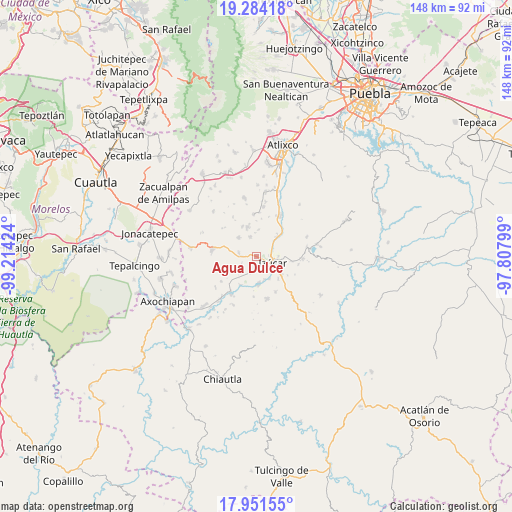
Agua Dulce GPS coordinates[2]
18° 37' 9.012" North, 98° 30' 39.996" West
| Map corner | latitude | longitude |
|---|---|---|
| Upper-left | 19.28418°, | -99.21424° |
| Center: | 18.61917°, | -98.51111° |
| Lower-right: | 17.95155°, | -97.80799° |
| Map W x H: | 148.2×148.2 km | = 92.1×92.1mi |
| max Lat: | 32.7° ⇑71.2% North |
| Agua Dulce: | 18.61917° |
| min Lat: | ⇓28.8% South 14.53588° |
| min Long | Agua Dulce | max Long |
| -117.105° | -98.51111° | -86.73105° |
| W 57.1%⇐ | ⇒42.9% E |
Elevation
Elevation of Agua Dulce is 1288 m = 4226 ft, and this is 34.3 m = 113 ft above average elevation for this country.
| Max E: |
3497 m = 11473 ft | 53.1% |
| Agua Dulce | 1288 m 4226 ft | |
| Avg. | 1253.7 m = 4113 ft | |
Min E: |
-1 m = -3 ft | 46.9% |
See also: Mexico elevation on elevation.city.
Geographical zone
Agua Dulce is located in North Torrid zone (between Equator and Tropic of Cancer). Distance of this Northern Tropic circle is 535.7 km =332.9 mi to North.| Distance of | km | miles | from Agua Dulce |
|---|---|---|---|
| North Pole | 7936.8 | 4931.7 | to North |
| Arctic Circle | 5330.9 | 3312.5 | to North |
| Tropic Cancer | 535.7 | 332.9 | to North |
| Equator | 2070.3 | 1286.4 | to South |


Nearby cities:
15 places around Agua Dulce: (largest is in red/bold)
• Ayutla
8.3 km =5.2 mi,  175°
175°
• Casa Blanca (Cuyotliapa)
3.8 km =2.4 mi, 182°
• Coatepec
7.4 km =4.6 mi,  316°
316°
• Cuexpala
5.1 km =3.2 mi,  280°
280°
• Izúcar de Matamoros
5.6 km =3.5 mi,  110°
110°
• La Galarza
8 km =5 mi,  47°
47°
• Matzaco
7.1 km =4.4 mi,  159°
159°
• Puctla
7.6 km =4.7 mi,  150°
150°
• San Félix Rijo
4.1 km =2.5 mi,  271°
271°
• San Juan Colón
6.8 km =4.2 mi,  226°
226°
• San Nicolás Tolentino
7.6 km =4.7 mi,  174°
174°
• Tepapayeca
6 km =3.7 mi,  341°
341°
• Tilapa
4.9 km =3 mi,  240°
240°
• Tlapanalá
8.9 km =5.5 mi, 343°
• Zolonquiapa
5.1 km =3.2 mi,  199°
199°
Sources, notices
• [Note1] Compared only with cities in Mexico existing in our database
• [Src1] Map data: © OpenStreetMap contributors (CC-BY-SA)
• [Src2] Other city data from geonames.org with taken over terms of usage.
• [Src3] Geographical zone / Annual Mean Temperature by Robert A. Rohde @ Wikipedia
