Temaxcalapa de Gabino Barreda geodata
Temaxcalapa de Gabino Barreda (Puebla) is a populated place; located in Mexico in America/Mexico_City (GMT-6) time zone. With population of 635 people, there are 13639 cities with bigger population in this country. Compared to other cities in Mexico, 71.9% of cities are located further ↑North; 56% of cities are located further ←West and 56.5% of cities have higher elevation than Temaxcalapa de Gabino Barreda. Note1
Current local time in Temaxcalapa de Gabino Barreda:
11:15 AM, MondayDifference from your time zone: hours


Temaxcalapa de Gabino Barreda GPS coordinates[2]
18° 33' 15.012" North, 98° 36' 21.996" West
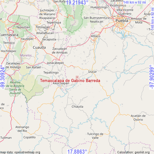
| Map corner | latitude | longitude |
|---|---|---|
| Upper-left | 19.21943°, | -99.30924° |
| Center: | 18.55417°, | -98.60611° |
| Lower-right: | 17.8863°, | -97.90299° |
| Map W x H: | 148.2×148.2 km | = 92.1×92.1mi |
| max Lat: | 32.7° ⇑71.9% North |
| Temaxcalapa de Gabino Barreda: | 18.55417° |
| min Lat: | ⇓28.1% South 14.53588° |
| min Long | Temaxcalapa de | max Long |
| -117.105° | -98.60611° | -86.73105° |
| W 56%⇐ | ⇒44% E |
Elevation
Elevation of Temaxcalapa de Gabino Barreda is 1140 m = 3740 ft, and this is 113.7 m = 373 ft below average elevation for this country.
| Max E: |
3497 m = 11473 ft | 56.5% |
| Avg. | 1253.7 m = 4113 ft | |
| Temaxcalapa de Gabino Barreda | 1140 m = 3740 ft | |
Min E: |
-1 m = -3 ft | 43.5% |
See also: Mexico elevation on elevation.city.
Geographical zone
Temaxcalapa de Gabino Barreda is located in North Torrid zone (between Equator and Tropic of Cancer). Distance of this Northern Tropic circle is 542.9 km =337.3 mi to North.| Distance of | km | miles | from Temaxcalapa de Gabino Barreda |
|---|---|---|---|
| North Pole | 7944 | 4936.2 | to North |
| Arctic Circle | 5338.1 | 3316.9 | to North |
| Tropic Cancer | 542.9 | 337.3 | to North |
| Equator | 2063 | 1281.9 | to South |


Nearby cities:
15 places around Temaxcalapa de Gabino Barreda: (largest is in red/bold)
• Ahuehuetzingo
8.1 km =5 mi,  202°
202°
• Atencingo
4.5 km =2.8 mi,  179°
179°
• Atzala
5.7 km =3.5 mi,  98°
98°
• Chietla
4.7 km =2.9 mi,  142°
142°
• Cuexpala
9.5 km =5.9 mi,  31°
31°
• Don Roque
8.6 km =5.3 mi, 195°
• Pueblo Nuevo de Porfirio Díaz
7 km =4.3 mi,  131°
131°
• San Félix Rijo
9.4 km =5.8 mi,  38°
38°
• San Isidro el Organal
2.6 km =1.6 mi,  221°
221°
• San Juan Colón
5.7 km =3.5 mi,  63°
63°
• San Miguel la Toma
4.5 km =2.8 mi, 135°
• San Nicolás Tenexcalco
8.2 km =5.1 mi,  172°
172°
• Tilapa
7.5 km =4.7 mi,  50°
50°
• Viborillas de Hidalgo
7.6 km =4.7 mi,  154°
154°
• Zolonquiapa
8.7 km =5.4 mi,  73°
73°
Sources, notices
• [Note1] Compared only with cities in Mexico existing in our database
• [Src1] Map data: © OpenStreetMap contributors (CC-BY-SA)
• [Src2] Other city data from geonames.org with taken over terms of usage.
• [Src3] Geographical zone / Annual Mean Temperature by Robert A. Rohde @ Wikipedia
