Tepapayeca geodata
Tepapayeca (Puebla) is a populated place; located in Mexico in America/Mexico_City (GMT-6) time zone. With population of 1,335 people, there are 6510 cities with bigger population in this country. Compared to other cities in Mexico, 70.6% of cities are located further ↑North; 56.9% of cities are located further ←West and 51.2% of cities have higher elevation than Tepapayeca. Note1


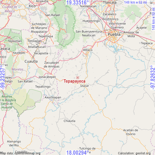
Tepapayeca GPS coordinates[2]
18° 40' 13.296" North, 98° 31' 45.984" West
| Map corner | latitude | longitude |
|---|---|---|
| Upper-left | 19.33516°, | -99.23257° |
| Center: | 18.67036°, | -98.52944° |
| Lower-right: | 18.00294°, | -97.82632° |
| Map W x H: | 148.1×148.1 km | = 92×92mi |
| max Lat: | 32.7° ⇑70.6% North |
| Tepapayeca: | 18.67036° |
| min Lat: | ⇓29.4% South 14.53588° |
| min Long | Tepapayeca | max Long |
| -117.105° | -98.52944° | -86.73105° |
| W 56.9%⇐ | ⇒43.1% E |
Elevation
Elevation of Tepapayeca is 1372 m = 4501 ft, and this is 118.3 m = 388 ft above average elevation for this country.
| Max E: |
3497 m = 11473 ft | 51.2% |
| Tepapayeca | 1372 m 4501 ft | |
| Avg. | 1253.7 m = 4113 ft | |
Min E: |
-1 m = -3 ft | 48.8% |
See also: Mexico elevation on elevation.city.
Geographical zone
Tepapayeca is located in North Torrid zone (between Equator and Tropic of Cancer). Distance of this Northern Tropic circle is 530 km =329.3 mi to North.| Distance of | km | miles | from Tepapayeca |
|---|---|---|---|
| North Pole | 7931.1 | 4928.2 | to North |
| Arctic Circle | 5325.2 | 3308.9 | to North |
| Tropic Cancer | 530 | 329.3 | to North |
| Equator | 2075.9 | 1289.9 | to South |


Nearby cities:
15 places around Tepapayeca: (largest is in red/bold)
• Agua Dulce
6 km =3.7 mi,  161°
161°
• Casa Blanca (Cuyotliapa)
9.6 km =6 mi,  169°
169°
• Coatepec
3.2 km =2 mi,  264°
264°
• Colonia las Palmas
3.6 km =2.2 mi,  323°
323°
• Cuexpala
5.7 km =3.5 mi,  212°
212°
• La Galarza
7.8 km =4.8 mi,  92°
92°
• San Diego el Organal
6.9 km =4.3 mi,  11°
11°
• San Félix Rijo
6 km =3.7 mi,  201°
201°
• San Juan Vallarta
7.6 km =4.7 mi,  23°
23°
• Santiago Tetla
9.3 km =5.8 mi,  355°
355°
• Santo Domingo Ayotlicha
7.5 km =4.7 mi, 318°
• Tezonteopan de Bonilla
9.5 km =5.9 mi, 24°
• Tilapa
8.5 km =5.3 mi, 195°
• Tlapanalá
2.9 km =1.8 mi,  347°
347°
• Tlapetlahuaya
10.4 km =6.5 mi,  334°
334°
Sources, notices
• [Note1] Compared only with cities in Mexico existing in our database
• [Src1] Map data: © OpenStreetMap contributors (CC-BY-SA)
• [Src2] Other city data from geonames.org with taken over terms of usage.
• [Src3] Geographical zone / Annual Mean Temperature by Robert A. Rohde @ Wikipedia
