San Juan Tepulco geodata
San Juan Tepulco (Puebla) is a populated place; located in Mexico in America/Mexico_City (GMT-6) time zone. With population of 8,232 people, there are 1154 cities with bigger population in this country. Compared to other cities in Mexico, 62.8% of cities are located further ↑North; 63.7% of cities are located further ←West and 94.4% of cities have lower elevation than San Juan Tepulco. Note1


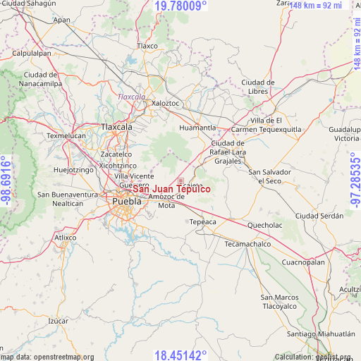
San Juan Tepulco GPS coordinates[2]
19° 7' 1.524" North, 97° 59' 18.492" West
| Map corner | latitude | longitude |
|---|---|---|
| Upper-left | 19.78009°, | -98.6916° |
| Center: | 19.11709°, | -97.98847° |
| Lower-right: | 18.45142°, | -97.28535° |
| Map W x H: | 147.7×147.7 km | = 91.8×91.8mi |
| max Lat: | 32.7° ⇑62.8% North |
| San Juan Tepulco: | 19.11709° |
| min Lat: | ⇓37.2% South 14.53588° |
| min Long | San Juan Tepulc | max Long |
| -117.105° | -97.98847° | -86.73105° |
| W 63.7%⇐ | ⇒36.3% E |
Elevation
Elevation of San Juan Tepulco is 2581 m = 8468 ft, and this is 1327.3 m = 4355 ft above average elevation for this country.
| Max E: |
3497 m = 11473 ft | 5.6% |
| San Juan Tepulco | 2581 m 8468 ft | |
| Avg. | 1253.7 m = 4113 ft | |
Min E: |
-1 m = -3 ft | 94.4% |
See also: Mexico elevation on elevation.city.
Geographical zone
San Juan Tepulco is located in North Torrid zone (between Equator and Tropic of Cancer). Distance of this Northern Tropic circle is 480.3 km =298.4 mi to North.| Distance of | km | miles | from San Juan Tepulco |
|---|---|---|---|
| North Pole | 7881.4 | 4897.3 | to North |
| Arctic Circle | 5275.6 | 3278.1 | to North |
| Tropic Cancer | 480.3 | 298.4 | to North |
| Equator | 2125.6 | 1320.8 | to South |


Nearby cities:
15 places around San Juan Tepulco: (largest is in red/bold)
• Acajete
3.8 km =2.4 mi,  99°
99°
• Amozoc de Mota
9.9 km =6.2 mi,  216°
216°
• Apango de Zaragoza
7.4 km =4.6 mi,  136°
136°
• Concepción Capulac (La Ex-Hacienda)
8.1 km =5 mi,  251°
251°
• El Rincón Citlaltépetl
10.8 km =6.7 mi,  66°
66°
• Ignacio Zaragoza
10.4 km =6.5 mi,  226°
226°
• La Magdalena Tetela Morelos
9 km =5.6 mi,  146°
146°
• San Agustín Tlaxco
6.8 km =4.2 mi,  182°
182°
• San Antonio Tlacamilco
8.6 km =5.3 mi,  134°
134°
• San Jacinto
10.7 km =6.6 mi, 230°
• San Jerónimo Ocotitla
9.9 km =6.2 mi,  164°
164°
• San Miguel Espejo
8.6 km =5.3 mi, 253°
• Santa María Nenetzintla
7.4 km =4.6 mi, 161°
• Tepatlaxco de Hidalgo
4.3 km =2.7 mi, 158°
• Tlacamilco
8.8 km =5.5 mi,  121°
121°
Sources, notices
• [Note1] Compared only with cities in Mexico existing in our database
• [Src1] Map data: © OpenStreetMap contributors (CC-BY-SA)
• [Src2] Other city data from geonames.org with taken over terms of usage.
• [Src3] Geographical zone / Annual Mean Temperature by Robert A. Rohde @ Wikipedia
