San Vicente Tancuayalab geodata
San Vicente Tancuayalab (San Luis Potosí) is a seat of a second-order administrative division; located in Mexico in America/Mexico_City (GMT-6) time zone. With population of 6,444 people, there are 1452 cities with bigger population in this country. Compared to other cities in Mexico, 82.6% of cities are located further ↓South; 56.2% of cities are located further ←West and 84.3% of cities have higher elevation than San Vicente Tancuayalab. Note1
Current local time in San Vicente Tancuayalab:
09:49 PM, TuesdayDifference from your time zone: hours


San Vicente Tancuayalab GPS coordinates[2]
21° 43' 7.896" North, 98° 35' 15.684" West
| Map corner | latitude | longitude |
|---|---|---|
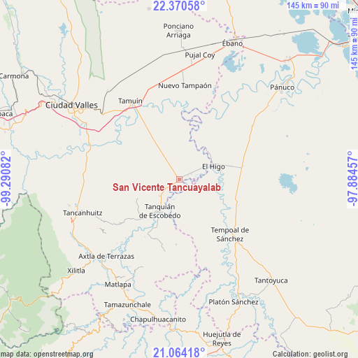
| Upper-left | 22.37058°, | -99.29082° |
| Center: | 21.71886°, | -98.58769° |
| Lower-right: | 21.06418°, | -97.88457° |
| Map W x H: | 145.3×145.3 km | = 90.3×90.3mi |
| max Lat: | 32.7° ⇑17.4% North |
| San Vicente Tancuayalab: | 21.71886° |
| min Lat: | ⇓82.6% South 14.53588° |
| min Long | San Vicente Tan | max Long |
| -117.105° | -98.58769° | -86.73105° |
| W 56.2%⇐ | ⇒43.8% E |
Elevation
Elevation of San Vicente Tancuayalab is 49 m = 161 ft, and this is 1204.7 m = 3952 ft below average elevation for this country.
| Max E: |
3497 m = 11473 ft | 84.3% |
| Avg. | 1253.7 m = 4113 ft | |
| San Vicente Tancuayalab | 49 m = 161 ft | |
Min E: |
-1 m = -3 ft | 15.7% |
See also: Mexico elevation on elevation.city.
Geographical zone
San Vicente Tancuayalab is located in North Torrid zone (between Equator and Tropic of Cancer). Distance of this Northern Tropic circle is 191 km =118.7 mi to North.| Distance of | km | miles | from San Vicente Tancuayalab |
|---|---|---|---|
| North Pole | 7592.2 | 4717.6 | to North |
| Arctic Circle | 4986.3 | 3098.3 | to North |
| Tropic Cancer | 191 | 118.7 | to North |
| Equator | 2414.9 | 1500.5 | to South |


Nearby cities:
15 places around San Vicente Tancuayalab: (largest is in red/bold)
• Bellavista
12.3 km =7.6 mi,  101°
101°
• Cuve de Badeas
18.7 km =11.6 mi,  85°
85°
• El Chote
16.2 km =10.1 mi,  49°
49°
• El Higo
15 km =9.3 mi,  69°
69°
• El Hoxton
7.9 km =4.9 mi, 93°
• El Hule Nuevo
9.8 km =6.1 mi,  160°
160°
• El Pueblito
16.2 km =10.1 mi,  56°
56°
• El Sasub
5.5 km =3.4 mi, 64°
• El Álamo
3.9 km =2.4 mi, 62°
• Las Badeas
18.3 km =11.4 mi,  82°
82°
• Las Lomas
14.6 km =9.1 mi,  230°
230°
• Sagrada Familia
10.3 km =6.4 mi, 228°
• San Francisco Cuayalab
13.5 km =8.4 mi,  276°
276°
• Santa Elena
10.3 km =6.4 mi,  250°
250°
• Tanquián de Escobedo
14.8 km =9.2 mi,  211°
211°
Sources, notices
• [Note1] Compared only with cities in Mexico existing in our database
• [Src1] Map data: © OpenStreetMap contributors (CC-BY-SA)
• [Src2] Other city data from geonames.org with taken over terms of usage.
• [Src3] Geographical zone / Annual Mean Temperature by Robert A. Rohde @ Wikipedia
