El Hoxton geodata
El Hoxton (Veracruz) is a populated place; located in Mexico in America/Mexico_City (GMT-6) time zone. With population of 751 people, there are 11671 cities with bigger population in this country. Compared to other cities in Mexico, 82.5% of cities are located further ↓South; 57.1% of cities are located further ←West and 86.3% of cities have higher elevation than El Hoxton. Note1


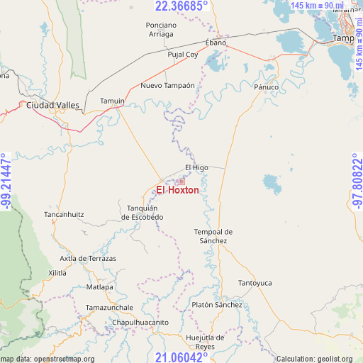
El Hoxton GPS coordinates[2]
21° 42' 54.432" North, 98° 30' 40.824" West
| Map corner | latitude | longitude |
|---|---|---|
| Upper-left | 22.36685°, | -99.21447° |
| Center: | 21.71512°, | -98.51134° |
| Lower-right: | 21.06042°, | -97.80822° |
| Map W x H: | 145.3×145.3 km | = 90.3×90.3mi |
| max Lat: | 32.7° ⇑17.5% North |
| El Hoxton: | 21.71512° |
| min Lat: | ⇓82.5% South 14.53588° |
| min Long | El Hoxton | max Long |
| -117.105° | -98.51134° | -86.73105° |
| W 57.1%⇐ | ⇒42.9% E |
Elevation
Elevation of El Hoxton is 37 m = 121 ft, and this is 1216.7 m = 3992 ft below average elevation for this country.
| Max E: |
3497 m = 11473 ft | 86.3% |
| Avg. | 1253.7 m = 4113 ft | |
| El Hoxton | 37 m = 121 ft | |
Min E: |
-1 m = -3 ft | 13.7% |
See also: Mexico elevation on elevation.city.
Geographical zone
El Hoxton is located in North Torrid zone (between Equator and Tropic of Cancer). Distance of this Northern Tropic circle is 191.4 km =118.9 mi to North.| Distance of | km | miles | from El Hoxton |
|---|---|---|---|
| North Pole | 7592.6 | 4717.8 | to North |
| Arctic Circle | 4986.7 | 3098.6 | to North |
| Tropic Cancer | 191.4 | 118.9 | to North |
| Equator | 2414.5 | 1500.3 | to South |


Nearby cities:
15 places around El Hoxton: (largest is in red/bold)
• Bellavista
4.7 km =2.9 mi,  116°
116°
• Corozal
19.3 km =12 mi,  193°
193°
• Cuve de Badeas
10.9 km =6.8 mi,  80°
80°
• Ejido Rancho Alegre
16.4 km =10.2 mi,  88°
88°
• El Chote
11.8 km =7.3 mi,  22°
22°
• El Higo
8.4 km =5.2 mi,  46°
46°
• El Hule Nuevo
10 km =6.2 mi,  207°
207°
• El Pueblito
11 km =6.8 mi,  30°
30°
• El Sasub
4 km =2.5 mi,  313°
313°
• El Álamo
5 km =3.1 mi,  296°
296°
• Las Badeas
10.6 km =6.6 mi,  73°
73°
• Sagrada Familia
16.9 km =10.5 mi,  247°
247°
• San Vicente Tancuayalab
7.9 km =4.9 mi,  273°
273°
• Santa Elena
17.8 km =11.1 mi,  260°
260°
• Tanquián de Escobedo
19.8 km =12.3 mi,  232°
232°
Sources, notices
• [Note1] Compared only with cities in Mexico existing in our database
• [Src1] Map data: © OpenStreetMap contributors (CC-BY-SA)
• [Src2] Other city data from geonames.org with taken over terms of usage.
• [Src3] Geographical zone / Annual Mean Temperature by Robert A. Rohde @ Wikipedia
