Santiago Ixcuintepec geodata
Santiago Ixcuintepec (Oaxaca) is a populated place; located in Mexico in America/Mexico_City (GMT-6) time zone. With population of 1,361 people, there are 6384 cities with bigger population in this country. Compared to other cities in Mexico, 89.8% of cities are located further ↑North; 83% of cities are located further ←West and 62.2% of cities have higher elevation than Santiago Ixcuintepec. Note1
Current local time in Santiago Ixcuintepec:
08:36 AM, WednesdayDifference from your time zone: hours


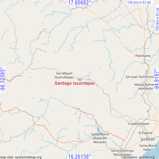
Santiago Ixcuintepec GPS coordinates[2]
16° 56' 7.44" North, 95° 37' 22.152" West
| Map corner | latitude | longitude |
|---|---|---|
| Upper-left | 17.60682°, | -96.32595° |
| Center: | 16.9354°, | -95.62282° |
| Lower-right: | 16.26158°, | -94.9197° |
| Map W x H: | 149.6×149.6 km | = 93×93mi |
| max Lat: | 32.7° ⇑89.8% North |
| Santiago Ixcuintepec: | 16.9354° |
| min Lat: | ⇓10.2% South 14.53588° |
| min Long | Santiago Ixcuin | max Long |
| -117.105° | -95.62282° | -86.73105° |
| W 83%⇐ | ⇒17% E |
Elevation
Elevation of Santiago Ixcuintepec is 869 m = 2851 ft, and this is 384.7 m = 1262 ft below average elevation for this country.
| Max E: |
3497 m = 11473 ft | 62.2% |
| Avg. | 1253.7 m = 4113 ft | |
| Santiago Ixcuintepec | 869 m = 2851 ft | |
Min E: |
-1 m = -3 ft | 37.8% |
See also: Mexico elevation on elevation.city.
Geographical zone
Santiago Ixcuintepec is located in North Torrid zone (between Equator and Tropic of Cancer). Distance of this Northern Tropic circle is 722.9 km =449.2 mi to North.| Distance of | km | miles | from Santiago Ixcuintepec |
|---|---|---|---|
| North Pole | 8124 | 5048 | to North |
| Arctic Circle | 5518.1 | 3428.8 | to North |
| Tropic Cancer | 722.9 | 449.2 | to North |
| Equator | 1883 | 1170 | to South |


Nearby cities:
15 places around Santiago Ixcuintepec: (largest is in red/bold)
• Guadalupe Guevea
23.3 km =14.5 mi,  158°
158°
• Guadalupe Victoria
24.5 km =15.2 mi,  259°
259°
• Guigovelaga
18.8 km =11.7 mi,  109°
109°
• San Juan Mazatlán
21.5 km =13.4 mi,  60°
60°
• San Lucas Camotlán
9.7 km =6 mi,  276°
276°
• San Miguel
22.2 km =13.8 mi, 111°
• San Miguel Quetzaltepec
15.2 km =9.4 mi,  286°
286°
• San Pedro Acatlán Grande
16.8 km =10.4 mi,  40°
40°
• San Pedro Chimaltepec
7.8 km =4.8 mi,  329°
329°
• San Pedro Ocotepec
23.8 km =14.8 mi, 275°
• Santa Cruz Ocotal
21.9 km =13.6 mi, 283°
• Santa Margarita Huitepec
5 km =3.1 mi,  273°
273°
• Santa María Nativitas Coatlán
13.2 km =8.2 mi,  131°
131°
• Santiago Malacatepec
9.2 km =5.7 mi,  10°
10°
• Santiago Quiavicuzas
12.8 km =8 mi,  230°
230°
Sources, notices
• [Note1] Compared only with cities in Mexico existing in our database
• [Src1] Map data: © OpenStreetMap contributors (CC-BY-SA)
• [Src2] Other city data from geonames.org with taken over terms of usage.
• [Src3] Geographical zone / Annual Mean Temperature by Robert A. Rohde @ Wikipedia
