Santiago Astata geodata
Santiago Astata (Oaxaca) is a seat of a second-order administrative division; located in Mexico in America/Mexico_City (GMT-6) time zone. With population of 2,207 people, there are 3977 cities with bigger population in this country. Compared to other cities in Mexico, 97.3% of cities are located further ↑North; 83% of cities are located further ←West and 86.1% of cities have higher elevation than Santiago Astata. Note1


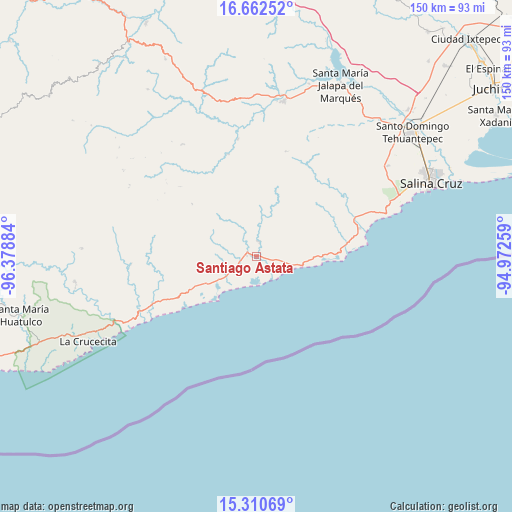
Santiago Astata GPS coordinates[2]
15° 59' 15.9" North, 95° 40' 32.556" West
| Map corner | latitude | longitude |
|---|---|---|
| Upper-left | 16.66252°, | -96.37884° |
| Center: | 15.98775°, | -95.67571° |
| Lower-right: | 15.31069°, | -94.97259° |
| Map W x H: | 150.3×150.3 km | = 93.4×93.4mi |
| max Lat: | 32.7° ⇑97.3% North |
| Santiago Astata: | 15.98775° |
| min Lat: | ⇓2.7% South 14.53588° |
| min Long | Santiago Astata | max Long |
| -117.105° | -95.67571° | -86.73105° |
| W 83%⇐ | ⇒17% E |
Elevation
Elevation of Santiago Astata is 38 m = 125 ft, and this is 1215.7 m = 3989 ft below average elevation for this country.
| Max E: |
3497 m = 11473 ft | 86.1% |
| Avg. | 1253.7 m = 4113 ft | |
| Santiago Astata | 38 m = 125 ft | |
Min E: |
-1 m = -3 ft | 13.9% |
See also: Mexico elevation on elevation.city.
Geographical zone
Santiago Astata is located in North Torrid zone (between Equator and Tropic of Cancer). Distance of this Northern Tropic circle is 828.2 km =514.6 mi to North.| Distance of | km | miles | from Santiago Astata |
|---|---|---|---|
| North Pole | 8229.4 | 5113.5 | to North |
| Arctic Circle | 5623.5 | 3494.3 | to North |
| Tropic Cancer | 828.2 | 514.6 | to North |
| Equator | 1777.7 | 1104.6 | to South |


Nearby cities:
15 places around Santiago Astata: (largest is in red/bold)
• Asunción Tlacolulita
35.1 km =21.8 mi,  351°
351°
• Barra de la Cruz
35.5 km =22.1 mi,  242°
242°
• El Carrizal
31.4 km =19.5 mi,  74°
74°
• El Coyul
16.5 km =10.3 mi, 240°
• El Morro
34 km =21.1 mi, 68°
• Guadalupe Victoria
23 km =14.3 mi,  277°
277°
• Rincón Bamba
27.3 km =17 mi,  79°
79°
• Río Seco
10 km =6.2 mi,  234°
234°
• San Matías Petacaltepec
30.7 km =19.1 mi,  312°
312°
• San Miguel Ecatepec
31.5 km =19.6 mi,  344°
344°
• San Miguel Tenango
32.2 km =20 mi,  15°
15°
• San Pedro Huamelula
4.5 km =2.8 mi,  11°
11°
• Santa María Huamelula
3 km =1.9 mi, 279°
• Santa María Zapotitlán
24.5 km =15.2 mi, 309°
• Tapanalá
5.7 km =3.5 mi,  245°
245°
Sources, notices
• [Note1] Compared only with cities in Mexico existing in our database
• [Src1] Map data: © OpenStreetMap contributors (CC-BY-SA)
• [Src2] Other city data from geonames.org with taken over terms of usage.
• [Src3] Geographical zone / Annual Mean Temperature by Robert A. Rohde @ Wikipedia
