Río Seco geodata
Río Seco (Oaxaca) is a populated place; located in Mexico in America/Mexico_City (GMT-6) time zone. With population of 654 people, there are 13268 cities with bigger population in this country. Compared to other cities in Mexico, 97.5% of cities are located further ↑North; 82.8% of cities are located further ←West and 89.4% of cities have higher elevation than Río Seco. Note1


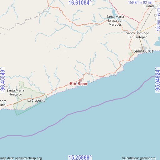
Río Seco GPS coordinates[2]
15° 56' 9.204" North, 95° 45' 8.496" West
| Map corner | latitude | longitude |
|---|---|---|
| Upper-left | 16.61084°, | -96.45549° |
| Center: | 15.93589°, | -95.75236° |
| Lower-right: | 15.25866°, | -95.04924° |
| Map W x H: | 150.3×150.4 km | = 93.4×93.5mi |
| max Lat: | 32.7° ⇑97.5% North |
| Río Seco: | 15.93589° |
| min Lat: | ⇓2.5% South 14.53588° |
| min Long | Río Seco | max Long |
| -117.105° | -95.75236° | -86.73105° |
| W 82.8%⇐ | ⇒17.2% E |
Elevation
Elevation of Río Seco is 26 m = 85 ft, and this is 1227.7 m = 4028 ft below average elevation for this country.
| Max E: |
3497 m = 11473 ft | 89.4% |
| Avg. | 1253.7 m = 4113 ft | |
| Río Seco | 26 m = 85 ft | |
Min E: |
-1 m = -3 ft | 10.6% |
See also: Mexico elevation on elevation.city.
Geographical zone
Río Seco is located in North Torrid zone (between Equator and Tropic of Cancer). Distance of this Northern Tropic circle is 834 km =518.2 mi to North.| Distance of | km | miles | from Río Seco |
|---|---|---|---|
| North Pole | 8235.2 | 5117.1 | to North |
| Arctic Circle | 5629.3 | 3497.9 | to North |
| Tropic Cancer | 834 | 518.2 | to North |
| Equator | 1771.9 | 1101 | to South |


Nearby cities:
15 places around Río Seco: (largest is in red/bold)
• Barra de la Cruz
25.7 km =16 mi,  245°
245°
• El Coyul
6.6 km =4.1 mi, 249°
• Guadalupe Victoria
17.1 km =10.6 mi,  301°
301°
• Merced del Potrero
36.2 km =22.5 mi,  289°
289°
• Rincón Bamba
36.6 km =22.7 mi,  73°
73°
• San Matías Petacaltepec
30.1 km =18.7 mi,  331°
331°
• San Miguel Ecatepec
36 km =22.4 mi,  359°
359°
• San Pablo Topiltepec
39.6 km =24.6 mi,  312°
312°
• San Pedro Huamelula
13.6 km =8.5 mi,  41°
41°
• Santa María Huamelula
8.2 km =5.1 mi, 39°
• Santa María Petatengo
28.9 km =18 mi,  277°
277°
• Santa María Xadani
34.4 km =21.4 mi,  272°
272°
• Santa María Zapotitlán
23.9 km =14.9 mi, 333°
• Santiago Astata
10 km =6.2 mi,  54°
54°
• Tapanalá
4.5 km =2.8 mi, 40°
Sources, notices
• [Note1] Compared only with cities in Mexico existing in our database
• [Src1] Map data: © OpenStreetMap contributors (CC-BY-SA)
• [Src2] Other city data from geonames.org with taken over terms of usage.
• [Src3] Geographical zone / Annual Mean Temperature by Robert A. Rohde @ Wikipedia
