San Quintín geodata
San Quintín (Chiapas) is a populated place; located in Mexico in America/Mexico_City (GMT-6) time zone. With population of 1,732 people, there are 5013 cities with bigger population in this country. Compared to other cities in Mexico, 94.9% of cities are located further ↑North; 96.5% of cities are located further ←West and 75.1% of cities have higher elevation than San Quintín. Note1


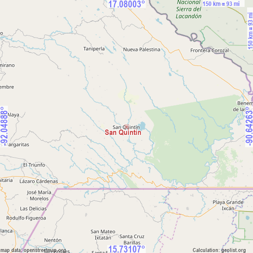
San Quintín GPS coordinates[2]
16° 24' 24.192" North, 91° 20' 44.7" West
| Map corner | latitude | longitude |
|---|---|---|
| Upper-left | 17.08003°, | -92.04888° |
| Center: | 16.40672°, | -91.34575° |
| Lower-right: | 15.73107°, | -90.64263° |
| Map W x H: | 150×150 km | = 93.2×93.2mi |
| max Lat: | 32.7° ⇑94.9% North |
| San Quintín: | 16.40672° |
| min Lat: | ⇓5.1% South 14.53588° |
| min Long | San Quintín | max Long |
| -117.105° | -91.34575° | -86.73105° |
| W 96.5%⇐ | ⇒3.5% E |
Elevation
Elevation of San Quintín is 220 m = 722 ft, and this is 1033.7 m = 3391 ft below average elevation for this country.
| Max E: |
3497 m = 11473 ft | 75.1% |
| Avg. | 1253.7 m = 4113 ft | |
| San Quintín | 220 m = 722 ft | |
Min E: |
-1 m = -3 ft | 24.9% |
See also: Mexico elevation on elevation.city.
Geographical zone
San Quintín is located in North Torrid zone (between Equator and Tropic of Cancer). Distance of this Northern Tropic circle is 781.7 km =485.7 mi to North.| Distance of | km | miles | from San Quintín |
|---|---|---|---|
| North Pole | 8182.8 | 5084.6 | to North |
| Arctic Circle | 5576.9 | 3465.3 | to North |
| Tropic Cancer | 781.7 | 485.7 | to North |
| Equator | 1824.3 | 1133.6 | to South |


Nearby cities:
15 places around San Quintín: (largest is in red/bold)
• Amador Hernández
14.6 km =9.1 mi,  5°
5°
• Emiliano Zapata
1.2 km =0.7 mi,  161°
161°
• Jerusalén
25.5 km =15.8 mi,  188°
188°
• La Soledad
15.8 km =9.8 mi,  316°
316°
• Nueva Providencia
3.6 km =2.2 mi,  210°
210°
• Nueva Sabanilla
20.6 km =12.8 mi,  139°
139°
• Nuevo Rodulfo Figueroa
22.5 km =14 mi, 156°
• Nuevo Santo Tomás
23.6 km =14.7 mi,  196°
196°
• Plan de Santo Tomás
25.3 km =15.7 mi,  271°
271°
• Ramón F. Balboa
9.7 km =6 mi, 320°
• Río Corozal
27.7 km =17.2 mi,  289°
289°
• San Antonio los Montes
27.6 km =17.1 mi,  217°
217°
• San Bartolo (El Puerto)
19.4 km =12.1 mi,  310°
310°
• Santa Lucía Ojo de Agua
23.6 km =14.7 mi, 265°
• Santa Rita Invernadero
19.4 km =12.1 mi, 272°
Sources, notices
• [Note1] Compared only with cities in Mexico existing in our database
• [Src1] Map data: © OpenStreetMap contributors (CC-BY-SA)
• [Src2] Other city data from geonames.org with taken over terms of usage.
• [Src3] Geographical zone / Annual Mean Temperature by Robert A. Rohde @ Wikipedia
