Amador Hernández geodata
Amador Hernández (Chiapas) is a populated place; located in Mexico in America/Mexico_City (GMT-6) time zone. With population of 540 people, there are 15727 cities with bigger population in this country. Compared to other cities in Mexico, 94.1% of cities are located further ↑North; 96.5% of cities are located further ←West and 71.7% of cities have higher elevation than Amador Hernández. Note1


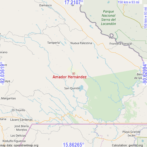
Amador Hernández GPS coordinates[2]
16° 32' 16.26" North, 91° 19' 59.016" West
| Map corner | latitude | longitude |
|---|---|---|
| Upper-left | 17.2107°, | -92.03619° |
| Center: | 16.53785°, | -91.33306° |
| Lower-right: | 15.86265°, | -90.62994° |
| Map W x H: | 149.9×149.9 km | = 93.1×93.1mi |
| max Lat: | 32.7° ⇑94.1% North |
| Amador Hernández: | 16.53785° |
| min Lat: | ⇓5.9% South 14.53588° |
| min Long | Amador Hernánd | max Long |
| -117.105° | -91.33306° | -86.73105° |
| W 96.5%⇐ | ⇒3.5% E |
Elevation
Elevation of Amador Hernández is 340 m = 1115 ft, and this is 913.7 m = 2998 ft below average elevation for this country.
| Max E: |
3497 m = 11473 ft | 71.7% |
| Avg. | 1253.7 m = 4113 ft | |
| Amador Hernández | 340 m = 1115 ft | |
Min E: |
-1 m = -3 ft | 28.3% |
See also: Mexico elevation on elevation.city.
Geographical zone
Amador Hernández is located in North Torrid zone (between Equator and Tropic of Cancer). Distance of this Northern Tropic circle is 767.1 km =476.7 mi to North.| Distance of | km | miles | from Amador Hernández |
|---|---|---|---|
| North Pole | 8168.2 | 5075.5 | to North |
| Arctic Circle | 5562.3 | 3456.3 | to North |
| Tropic Cancer | 767.1 | 476.7 | to North |
| Equator | 1838.8 | 1142.6 | to South |


Nearby cities:
15 places around Amador Hernández: (largest is in red/bold)
• El Zapotal
26.3 km =16.3 mi,  333°
333°
• Emiliano Zapata
15.7 km =9.8 mi,  183°
183°
• La Soledad
12.7 km =7.9 mi,  255°
255°
• Luis Espinoza
31.3 km =19.4 mi,  280°
280°
• Nueva Providencia
18 km =11.2 mi,  190°
190°
• Plan de Ayutla
30.6 km =19 mi,  4°
4°
• Plan de Santo Tomás
30 km =18.6 mi,  242°
242°
• Ramón F. Balboa
10.3 km =6.4 mi,  226°
226°
• Río Corozal
27.9 km =17.3 mi, 259°
• San Bartolo (El Puerto)
16.1 km =10 mi, 263°
• San Caralampio
24.3 km =15.1 mi,  336°
336°
• San José
20.4 km =12.7 mi, 340°
• San Quintín
14.6 km =9.1 mi, 185°
• Santa Lucía Ojo de Agua
29.9 km =18.6 mi, 236°
• Santa Rita Invernadero
24.9 km =15.5 mi, 236°
Sources, notices
• [Note1] Compared only with cities in Mexico existing in our database
• [Src1] Map data: © OpenStreetMap contributors (CC-BY-SA)
• [Src2] Other city data from geonames.org with taken over terms of usage.
• [Src3] Geographical zone / Annual Mean Temperature by Robert A. Rohde @ Wikipedia
