La Soledad geodata
La Soledad (Chiapas) is a populated place; located in Mexico in America/Mexico_City (GMT-6) time zone. With population of 993 people, there are 8774 cities with bigger population in this country. Compared to other cities in Mexico, 94.3% of cities are located further ↑North; 96.4% of cities are located further ←West and 73.8% of cities have higher elevation than La Soledad. Note1


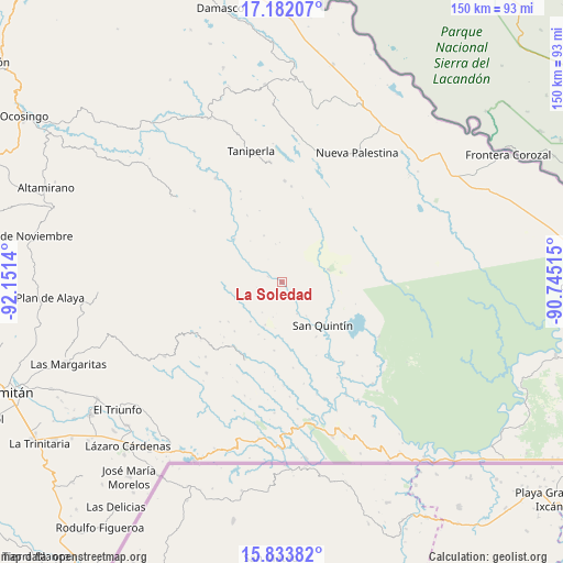
La Soledad GPS coordinates[2]
16° 30' 32.832" North, 91° 26' 53.772" West
| Map corner | latitude | longitude |
|---|---|---|
| Upper-left | 17.18207°, | -92.1514° |
| Center: | 16.50912°, | -91.44827° |
| Lower-right: | 15.83382°, | -90.74515° |
| Map W x H: | 149.9×149.9 km | = 93.1×93.1mi |
| max Lat: | 32.7° ⇑94.3% North |
| La Soledad: | 16.50912° |
| min Lat: | ⇓5.7% South 14.53588° |
| min Long | La Soledad | max Long |
| -117.105° | -91.44827° | -86.73105° |
| W 96.4%⇐ | ⇒3.6% E |
Elevation
Elevation of La Soledad is 261 m = 856 ft, and this is 992.7 m = 3257 ft below average elevation for this country.
| Max E: |
3497 m = 11473 ft | 73.8% |
| Avg. | 1253.7 m = 4113 ft | |
| La Soledad | 261 m = 856 ft | |
Min E: |
-1 m = -3 ft | 26.2% |
See also: Mexico elevation on elevation.city.
Geographical zone
La Soledad is located in North Torrid zone (between Equator and Tropic of Cancer). Distance of this Northern Tropic circle is 770.3 km =478.6 mi to North.| Distance of | km | miles | from La Soledad |
|---|---|---|---|
| North Pole | 8171.4 | 5077.5 | to North |
| Arctic Circle | 5565.5 | 3458.2 | to North |
| Tropic Cancer | 770.3 | 478.6 | to North |
| Equator | 1835.6 | 1140.6 | to South |


Nearby cities:
15 places around La Soledad: (largest is in red/bold)
• Amador Hernández
12.7 km =7.9 mi,  75°
75°
• Emiliano Zapata
16.9 km =10.5 mi,  137°
137°
• Luis Espinoza
20.5 km =12.7 mi,  295°
295°
• Nueva Providencia
17.1 km =10.6 mi,  148°
148°
• Plan de Santo Tomás
17.9 km =11.1 mi,  233°
233°
• Ramón F. Balboa
6.2 km =3.9 mi,  128°
128°
• Río Corozal
15.3 km =9.5 mi,  262°
262°
• San Bartolo (El Puerto)
4 km =2.5 mi,  289°
289°
• San José
23.1 km =14.4 mi,  13°
13°
• San Juan Bautista
20.8 km =12.9 mi, 255°
• San Juan Rómulo Calzada
22.2 km =13.8 mi,  308°
308°
• San Luis Potosí
23.5 km =14.6 mi, 296°
• San Quintín
15.8 km =9.8 mi, 136°
• Santa Lucía Ojo de Agua
18.3 km =11.4 mi,  223°
223°
• Santa Rita Invernadero
13.6 km =8.5 mi, 218°
Sources, notices
• [Note1] Compared only with cities in Mexico existing in our database
• [Src1] Map data: © OpenStreetMap contributors (CC-BY-SA)
• [Src2] Other city data from geonames.org with taken over terms of usage.
• [Src3] Geographical zone / Annual Mean Temperature by Robert A. Rohde @ Wikipedia
