San Nicolás geodata
San Nicolás (Guerrero) is a populated place; located in Mexico in America/Mexico_City (GMT-6) time zone. With population of 3,267 people, there are 2777 cities with bigger population in this country. Compared to other cities in Mexico, 94.9% of cities are located further ↑North; 57% of cities are located further ←West and 81.7% of cities have higher elevation than San Nicolás. Note1


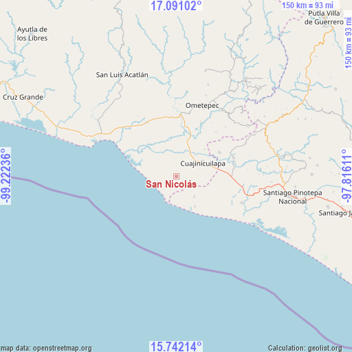
San Nicolás GPS coordinates[2]
16° 25' 3.9" North, 98° 31' 9.228" West
| Map corner | latitude | longitude |
|---|---|---|
| Upper-left | 17.09102°, | -99.22236° |
| Center: | 16.41775°, | -98.51923° |
| Lower-right: | 15.74214°, | -97.81611° |
| Map W x H: | 150×150 km | = 93.2×93.2mi |
| max Lat: | 32.7° ⇑94.9% North |
| San Nicolás: | 16.41775° |
| min Lat: | ⇓5.1% South 14.53588° |
| min Long | San Nicolás | max Long |
| -117.105° | -98.51923° | -86.73105° |
| W 57%⇐ | ⇒43% E |
Elevation
Elevation of San Nicolás is 73 m = 240 ft, and this is 1180.7 m = 3874 ft below average elevation for this country.
| Max E: |
3497 m = 11473 ft | 81.7% |
| Avg. | 1253.7 m = 4113 ft | |
| San Nicolás | 73 m = 240 ft | |
Min E: |
-1 m = -3 ft | 18.3% |
See also: Mexico elevation on elevation.city.
Geographical zone
San Nicolás is located in North Torrid zone (between Equator and Tropic of Cancer). Distance of this Northern Tropic circle is 780.4 km =484.9 mi to North.| Distance of | km | miles | from San Nicolás |
|---|---|---|---|
| North Pole | 8181.6 | 5083.8 | to North |
| Arctic Circle | 5575.7 | 3464.6 | to North |
| Tropic Cancer | 780.4 | 484.9 | to North |
| Equator | 1825.5 | 1134.3 | to South |


Nearby cities:
15 places around San Nicolás: (largest is in red/bold)
• Barajillas (Barajilla)
11.7 km =7.3 mi,  30°
30°
• Cerro del Indio (El Indio)
13.2 km =8.2 mi,  14°
14°
• Colonia Miguel Alemán Valdez
13.1 km =8.1 mi,  356°
356°
• Comaltepec
18.8 km =11.7 mi,  15°
15°
• Cuajinicuilapa
12.8 km =8 mi,  61°
61°
• El Pitahayo
12.8 km =8 mi, 355°
• El Quiza
16.9 km =10.5 mi,  46°
46°
• El Terrero
18.2 km =11.3 mi, 27°
• Llano Grande
15 km =9.3 mi,  147°
147°
• Maldonado
12.1 km =7.5 mi,  307°
307°
• Milpillas
19.3 km =12 mi, 18°
• Montecillos
3.7 km =2.3 mi,  142°
142°
• Santiago Tepextla
11.5 km =7.1 mi, 137°
• Santo Domingo Armenta
17.9 km =11.1 mi,  122°
122°
• Tierra Colorada
13.5 km =8.4 mi,  284°
284°
Sources, notices
• [Note1] Compared only with cities in Mexico existing in our database
• [Src1] Map data: © OpenStreetMap contributors (CC-BY-SA)
• [Src2] Other city data from geonames.org with taken over terms of usage.
• [Src3] Geographical zone / Annual Mean Temperature by Robert A. Rohde @ Wikipedia
