Llano Grande geodata
Llano Grande (Oaxaca) is a populated place; located in Mexico in America/Mexico_City (GMT-6) time zone. With population of 950 people, there are 9169 cities with bigger population in this country. Compared to other cities in Mexico, 95.6% of cities are located further ↑North; 58% of cities are located further ←West and 84.8% of cities have higher elevation than Llano Grande. Note1


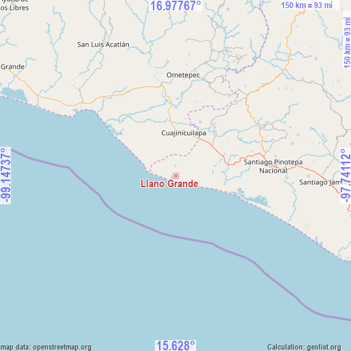
Llano Grande GPS coordinates[2]
16° 18' 14.4" North, 98° 26' 39.264" West
| Map corner | latitude | longitude |
|---|---|---|
| Upper-left | 16.97767°, | -99.14737° |
| Center: | 16.304°, | -98.44424° |
| Lower-right: | 15.628°, | -97.74112° |
| Map W x H: | 150.1×150.1 km | = 93.3×93.3mi |
| max Lat: | 32.7° ⇑95.6% North |
| Llano Grande: | 16.304° |
| min Lat: | ⇓4.4% South 14.53588° |
| min Long | Llano Grande | max Long |
| -117.105° | -98.44424° | -86.73105° |
| W 58%⇐ | ⇒42% E |
Elevation
Elevation of Llano Grande is 45 m = 148 ft, and this is 1208.7 m = 3966 ft below average elevation for this country.
| Max E: |
3497 m = 11473 ft | 84.8% |
| Avg. | 1253.7 m = 4113 ft | |
| Llano Grande | 45 m = 148 ft | |
Min E: |
-1 m = -3 ft | 15.2% |
See also: Mexico elevation on elevation.city.
Geographical zone
Llano Grande is located in North Torrid zone (between Equator and Tropic of Cancer). Distance of this Northern Tropic circle is 793.1 km =492.8 mi to North.| Distance of | km | miles | from Llano Grande |
|---|---|---|---|
| North Pole | 8194.2 | 5091.6 | to North |
| Arctic Circle | 5588.3 | 3472.4 | to North |
| Tropic Cancer | 793.1 | 492.8 | to North |
| Equator | 1812.8 | 1126.4 | to South |


Nearby cities:
15 places around Llano Grande: (largest is in red/bold)
• Barajillas (Barajilla)
22.8 km =14.2 mi,  354°
354°
• Cerro del Indio (El Indio)
25.9 km =16.1 mi, 349°
• Cuajinicuilapa
19.1 km =11.9 mi,  9°
9°
• El Ciruelo
20 km =12.4 mi,  85°
85°
• El Quiza
24.7 km =15.3 mi, 9°
• Lagunillas
24.2 km =15 mi,  78°
78°
• Montecillos
11.3 km =7 mi,  329°
329°
• San José Estancia Grande
21.7 km =13.5 mi,  71°
71°
• San Juan Bautista Lo de Soto
25.3 km =15.7 mi,  23°
23°
• San Nicolás
15 km =9.3 mi, 327°
• Santa María Cortijo
23.6 km =14.7 mi,  45°
45°
• Santiago Llano Grande
26.3 km =16.3 mi,  38°
38°
• Santiago Tepextla
4.1 km =2.5 mi,  356°
356°
• Santo Domingo Armenta
7.7 km =4.8 mi, 66°
• Tierra Colorada
26.5 km =16.5 mi,  307°
307°
Sources, notices
• [Note1] Compared only with cities in Mexico existing in our database
• [Src1] Map data: © OpenStreetMap contributors (CC-BY-SA)
• [Src2] Other city data from geonames.org with taken over terms of usage.
• [Src3] Geographical zone / Annual Mean Temperature by Robert A. Rohde @ Wikipedia
