Milpillas geodata
Milpillas (Guerrero) is a populated place; located in Mexico in America/Mexico_City (GMT-6) time zone. With population of 575 people, there are 14908 cities with bigger population in this country. Compared to other cities in Mexico, 93.8% of cities are located further ↑North; 57.8% of cities are located further ←West and 85.7% of cities have higher elevation than Milpillas. Note1


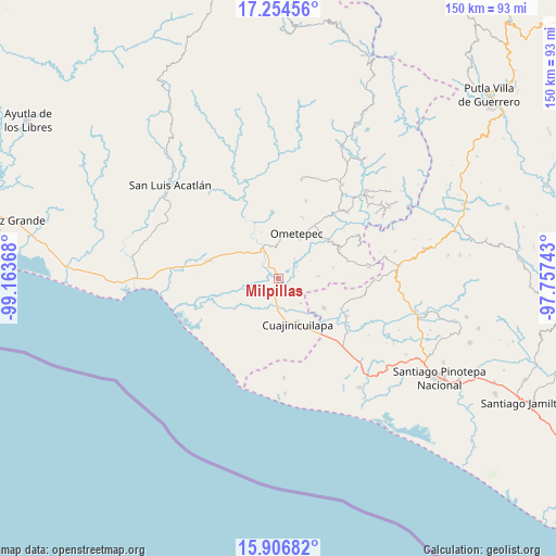
Milpillas GPS coordinates[2]
16° 34' 54.732" North, 98° 27' 37.98" West
| Map corner | latitude | longitude |
|---|---|---|
| Upper-left | 17.25456°, | -99.16368° |
| Center: | 16.58187°, | -98.46055° |
| Lower-right: | 15.90682°, | -97.75743° |
| Map W x H: | 149.9×149.9 km | = 93.1×93.1mi |
| max Lat: | 32.7° ⇑93.8% North |
| Milpillas: | 16.58187° |
| min Lat: | ⇓6.2% South 14.53588° |
| min Long | Milpillas | max Long |
| -117.105° | -98.46055° | -86.73105° |
| W 57.8%⇐ | ⇒42.2% E |
Elevation
Elevation of Milpillas is 40 m = 131 ft, and this is 1213.7 m = 3982 ft below average elevation for this country.
| Max E: |
3497 m = 11473 ft | 85.7% |
| Avg. | 1253.7 m = 4113 ft | |
| Milpillas | 40 m = 131 ft | |
Min E: |
-1 m = -3 ft | 14.3% |
See also: Mexico elevation on elevation.city.
Geographical zone
Milpillas is located in North Torrid zone (between Equator and Tropic of Cancer). Distance of this Northern Tropic circle is 762.2 km =473.6 mi to North.| Distance of | km | miles | from Milpillas |
|---|---|---|---|
| North Pole | 8163.3 | 5072.4 | to North |
| Arctic Circle | 5557.4 | 3453.2 | to North |
| Tropic Cancer | 762.2 | 473.6 | to North |
| Equator | 1843.7 | 1145.6 | to South |


Nearby cities:
15 places around Milpillas: (largest is in red/bold)
• Barajillas (Barajilla)
8.2 km =5.1 mi,  182°
182°
• Cerro del Indio (El Indio)
6.2 km =3.9 mi,  208°
208°
• Colonia Miguel Alemán Valdez
8.7 km =5.4 mi,  233°
233°
• Comaltepec
1.2 km =0.7 mi,  262°
262°
• Cruz de Corazón
12.5 km =7.8 mi,  9°
9°
• Cuajinicuilapa
13 km =8.1 mi,  157°
157°
• El Pitahayo
9 km =5.6 mi, 232°
• El Quiza
8.8 km =5.5 mi,  137°
137°
• El Terrero
3.1 km =1.9 mi,  133°
133°
• Huehuetán
12.1 km =7.5 mi,  299°
299°
• Las Vigas
10.6 km =6.6 mi,  2°
2°
• Ometepec
13.3 km =8.3 mi,  24°
24°
• Piedra Ancha
10.6 km =6.6 mi,  86°
86°
• San Juan de los Llanos
9.2 km =5.7 mi,  333°
333°
• Tenango
12.2 km =7.6 mi,  320°
320°
Sources, notices
• [Note1] Compared only with cities in Mexico existing in our database
• [Src1] Map data: © OpenStreetMap contributors (CC-BY-SA)
• [Src2] Other city data from geonames.org with taken over terms of usage.
• [Src3] Geographical zone / Annual Mean Temperature by Robert A. Rohde @ Wikipedia
