San Mateo Coatepec geodata
San Mateo Coatepec (Puebla) is a populated place; located in Mexico in America/Mexico_City (GMT-6) time zone. With population of 574 people, there are 14926 cities with bigger population in this country. Compared to other cities in Mexico, 68.5% of cities are located further ↑North; 55.6% of cities are located further ←West and 75.6% of cities have lower elevation than San Mateo Coatepec. Note1


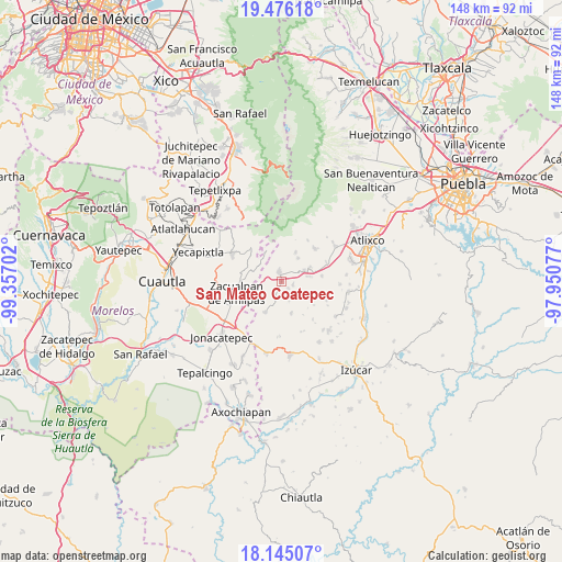
San Mateo Coatepec GPS coordinates[2]
18° 48' 42.984" North, 98° 39' 14.004" West
| Map corner | latitude | longitude |
|---|---|---|
| Upper-left | 19.47618°, | -99.35702° |
| Center: | 18.81194°, | -98.65389° |
| Lower-right: | 18.14507°, | -97.95077° |
| Map W x H: | 148×148 km | = 92×92mi |
| max Lat: | 32.7° ⇑68.5% North |
| San Mateo Coatepec: | 18.81194° |
| min Lat: | ⇓31.5% South 14.53588° |
| min Long | San Mateo Coate | max Long |
| -117.105° | -98.65389° | -86.73105° |
| W 55.6%⇐ | ⇒44.4% E |
Elevation
Elevation of San Mateo Coatepec is 2042 m = 6699 ft, and this is 788.3 m = 2586 ft above average elevation for this country.
| Max E: |
3497 m = 11473 ft | 24.4% |
| San Mateo Coatepec | 2042 m 6699 ft | |
| Avg. | 1253.7 m = 4113 ft | |
Min E: |
-1 m = -3 ft | 75.6% |
See also: Mexico elevation on elevation.city.
Geographical zone
San Mateo Coatepec is located in North Torrid zone (between Equator and Tropic of Cancer). Distance of this Northern Tropic circle is 514.2 km =319.5 mi to North.| Distance of | km | miles | from San Mateo Coatepec |
|---|---|---|---|
| North Pole | 7915.4 | 4918.4 | to North |
| Arctic Circle | 5309.5 | 3299.2 | to North |
| Tropic Cancer | 514.2 | 319.5 | to North |
| Equator | 2091.7 | 1299.7 | to South |


Nearby cities:
15 places around San Mateo Coatepec: (largest is in red/bold)
• Acteopan
8.3 km =5.2 mi,  229°
229°
• Cohuecán
7.8 km =4.8 mi,  245°
245°
• Huilango
8.3 km =5.2 mi,  65°
65°
• San Felipe Cuapexco
5.5 km =3.4 mi,  280°
280°
• San Felipe Tepemaxalco
8.7 km =5.4 mi,  163°
163°
• San Felipe Toctla
7.4 km =4.6 mi,  220°
220°
• San Francisco Tepango
5.8 km =3.6 mi,  298°
298°
• San Francisco Xochiteopan
3.2 km =2 mi,  104°
104°
• San Juan Amecac
2.6 km =1.6 mi,  347°
347°
• San Pedro Ixhuatepec
2.6 km =1.6 mi,  135°
135°
• Santa Cruz Cuautomatitla
8.6 km =5.3 mi,  356°
356°
• Santiago Atzitzihuacán
7.7 km =4.8 mi,  79°
79°
• Santiago Tochimizolco
7.7 km =4.8 mi,  36°
36°
• Tecuanipa
8.5 km =5.3 mi,  25°
25°
• Tulcingo
6.8 km =4.2 mi, 65°
Sources, notices
• [Note1] Compared only with cities in Mexico existing in our database
• [Src1] Map data: © OpenStreetMap contributors (CC-BY-SA)
• [Src2] Other city data from geonames.org with taken over terms of usage.
• [Src3] Geographical zone / Annual Mean Temperature by Robert A. Rohde @ Wikipedia
