Huilango geodata
Huilango (Puebla) is a populated place; located in Mexico in America/Mexico_City (GMT-6) time zone. With population of 899 people, there are 9699 cities with bigger population in this country. Compared to other cities in Mexico, 68% of cities are located further ↑North; 56.3% of cities are located further ←West and 67.4% of cities have lower elevation than Huilango. Note1


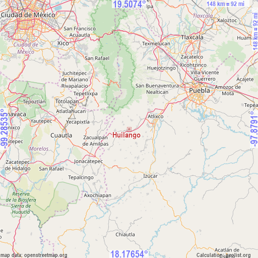
Huilango GPS coordinates[2]
18° 50' 35.844" North, 98° 34' 55.992" West
| Map corner | latitude | longitude |
|---|---|---|
| Upper-left | 19.5074°, | -99.28535° |
| Center: | 18.84329°, | -98.58222° |
| Lower-right: | 18.17654°, | -97.8791° |
| Map W x H: | 148×148 km | = 92×92mi |
| max Lat: | 32.7° ⇑68% North |
| Huilango: | 18.84329° |
| min Lat: | ⇓32% South 14.53588° |
| min Long | Huilango | max Long |
| -117.105° | -98.58222° | -86.73105° |
| W 56.3%⇐ | ⇒43.7% E |
Elevation
Elevation of Huilango is 1878 m = 6161 ft, and this is 624.3 m = 2048 ft above average elevation for this country.
| Max E: |
3497 m = 11473 ft | 32.6% |
| Huilango | 1878 m 6161 ft | |
| Avg. | 1253.7 m = 4113 ft | |
Min E: |
-1 m = -3 ft | 67.4% |
See also: Mexico elevation on elevation.city.
Geographical zone
Huilango is located in North Torrid zone (between Equator and Tropic of Cancer). Distance of this Northern Tropic circle is 510.7 km =317.3 mi to North.| Distance of | km | miles | from Huilango |
|---|---|---|---|
| North Pole | 7911.9 | 4916.2 | to North |
| Arctic Circle | 5306 | 3297 | to North |
| Tropic Cancer | 510.7 | 317.3 | to North |
| Equator | 2095.2 | 1301.9 | to South |


Nearby cities:
15 places around Huilango: (largest is in red/bold)
• Jerusalén
6.4 km =4 mi,  356°
356°
• La Magdalena Yancuitlalpan
7.5 km =4.7 mi,  354°
354°
• San Francisco Xochiteopan
6.2 km =3.9 mi,  225°
225°
• San Juan Amecac
8.1 km =5 mi,  263°
263°
• San Juan Tejupa
4.5 km =2.8 mi,  72°
72°
• San Martín Zacatempa
5.6 km =3.5 mi,  329°
329°
• San Mateo Coatepec
8.3 km =5.2 mi,  245°
245°
• San Miguel Aguacomulican
4.1 km =2.5 mi,  125°
125°
• San Pedro Ixhuatepec
7.8 km =4.8 mi, 226°
• Santa Catalina Tepanapa
6.2 km =3.9 mi, 330°
• Santiago Atzitzihuacán
2.1 km =1.3 mi,  178°
178°
• Santiago Tochimizolco
4 km =2.5 mi,  312°
312°
• Tecuanipa
5.7 km =3.5 mi,  317°
317°
• Tochimilco
5.4 km =3.4 mi,  12°
12°
• Tulcingo
1.6 km =1 mi, 245°
Sources, notices
• [Note1] Compared only with cities in Mexico existing in our database
• [Src1] Map data: © OpenStreetMap contributors (CC-BY-SA)
• [Src2] Other city data from geonames.org with taken over terms of usage.
• [Src3] Geographical zone / Annual Mean Temperature by Robert A. Rohde @ Wikipedia
