San Juan Amecac geodata
San Juan Amecac (Puebla) is a populated place; located in Mexico in America/Mexico_City (GMT-6) time zone. With population of 3,956 people, there are 2303 cities with bigger population in this country. Compared to other cities in Mexico, 68.2% of cities are located further ↑North; 55.5% of cities are located further ←West and 77.5% of cities have lower elevation than San Juan Amecac. Note1


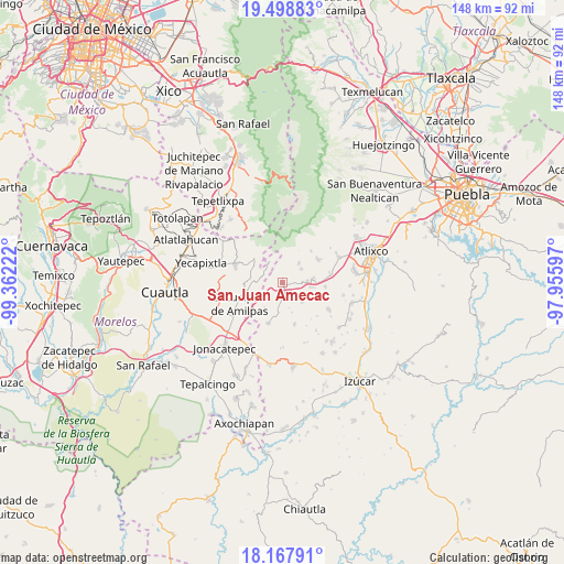
San Juan Amecac GPS coordinates[2]
18° 50' 4.884" North, 98° 39' 32.724" West
| Map corner | latitude | longitude |
|---|---|---|
| Upper-left | 19.49883°, | -99.36222° |
| Center: | 18.83469°, | -98.65909° |
| Lower-right: | 18.16791°, | -97.95597° |
| Map W x H: | 148×148 km | = 92×92mi |
| max Lat: | 32.7° ⇑68.2% North |
| San Juan Amecac: | 18.83469° |
| min Lat: | ⇓31.8% South 14.53588° |
| min Long | San Juan Amecac | max Long |
| -117.105° | -98.65909° | -86.73105° |
| W 55.5%⇐ | ⇒44.5% E |
Elevation
Elevation of San Juan Amecac is 2079 m = 6821 ft, and this is 825.3 m = 2708 ft above average elevation for this country.
| Max E: |
3497 m = 11473 ft | 22.5% |
| San Juan Amecac | 2079 m 6821 ft | |
| Avg. | 1253.7 m = 4113 ft | |
Min E: |
-1 m = -3 ft | 77.5% |
See also: Mexico elevation on elevation.city.
Geographical zone
San Juan Amecac is located in North Torrid zone (between Equator and Tropic of Cancer). Distance of this Northern Tropic circle is 511.7 km =318 mi to North.| Distance of | km | miles | from San Juan Amecac |
|---|---|---|---|
| North Pole | 7912.8 | 4916.8 | to North |
| Arctic Circle | 5307 | 3297.6 | to North |
| Tropic Cancer | 511.7 | 318 | to North |
| Equator | 2094.2 | 1301.3 | to South |


Nearby cities:
15 places around San Juan Amecac: (largest is in red/bold)
• Hueyapan
6.6 km =4.1 mi,  338°
338°
• Huilango
8.1 km =5 mi,  83°
83°
• San Antonio Alpanocan
7.2 km =4.5 mi,  310°
310°
• San Felipe Cuapexco
5.1 km =3.2 mi,  252°
252°
• San Francisco Tepango
4.5 km =2.8 mi,  273°
273°
• San Francisco Xochiteopan
5 km =3.1 mi,  132°
132°
• San Martín Zacatempa
7.9 km =4.9 mi,  41°
41°
• San Mateo Coatepec
2.6 km =1.6 mi,  167°
167°
• San Pedro Ixhuatepec
5 km =3.1 mi,  151°
151°
• Santa Catalina Tepanapa
8.1 km =5 mi, 38°
• Santa Cruz Cuautomatitla
6.1 km =3.8 mi,  359°
359°
• Santiago Atzitzihuacán
8.2 km =5.1 mi,  97°
97°
• Santiago Tochimizolco
6.3 km =3.9 mi,  54°
54°
• Tecuanipa
6.7 km =4.2 mi, 39°
• Tulcingo
6.7 km =4.2 mi,  87°
87°
Sources, notices
• [Note1] Compared only with cities in Mexico existing in our database
• [Src1] Map data: © OpenStreetMap contributors (CC-BY-SA)
• [Src2] Other city data from geonames.org with taken over terms of usage.
• [Src3] Geographical zone / Annual Mean Temperature by Robert A. Rohde @ Wikipedia
