San Juan del Río geodata
San Juan del Río (Oaxaca) is a populated place; located in Mexico in America/Mexico_City (GMT-6) time zone. With population of 1,231 people, there are 7050 cities with bigger population in this country. Compared to other cities in Mexico, 90.6% of cities are located further ↑North; 81.6% of cities are located further ←West and 55.7% of cities have higher elevation than San Juan del Río. Note1


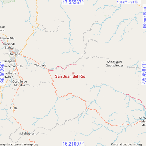
San Juan del Río GPS coordinates[2]
16° 53' 2.652" North, 96° 9' 35.388" West
| Map corner | latitude | longitude |
|---|---|---|
| Upper-left | 17.55567°, | -96.86296° |
| Center: | 16.88407°, | -96.15983° |
| Lower-right: | 16.21007°, | -95.45671° |
| Map W x H: | 149.6×149.6 km | = 93×93mi |
| max Lat: | 32.7° ⇑90.6% North |
| San Juan del Río: | 16.88407° |
| min Lat: | ⇓9.4% South 14.53588° |
| min Long | San Juan del R� | max Long |
| -117.105° | -96.15983° | -86.73105° |
| W 81.6%⇐ | ⇒18.4% E |
Elevation
Elevation of San Juan del Río is 1173 m = 3848 ft, and this is 80.7 m = 265 ft below average elevation for this country.
| Max E: |
3497 m = 11473 ft | 55.7% |
| Avg. | 1253.7 m = 4113 ft | |
| San Juan del Río | 1173 m = 3848 ft | |
Min E: |
-1 m = -3 ft | 44.3% |
See also: Mexico elevation on elevation.city.
Geographical zone
San Juan del Río is located in North Torrid zone (between Equator and Tropic of Cancer). Distance of this Northern Tropic circle is 728.6 km =452.7 mi to North.| Distance of | km | miles | from San Juan del Río |
|---|---|---|---|
| North Pole | 8129.7 | 5051.6 | to North |
| Arctic Circle | 5523.8 | 3432.3 | to North |
| Tropic Cancer | 728.6 | 452.7 | to North |
| Equator | 1877.3 | 1166.5 | to South |


Nearby cities:
15 places around San Juan del Río: (largest is in red/bold)
• Ayutla
18.3 km =11.4 mi,  29°
29°
• El Duraznal
16.4 km =10.2 mi,  357°
357°
• Lachicocana
19.8 km =12.3 mi, 359°
• Las Peñas
18.9 km =11.7 mi,  48°
48°
• Llano Crucero
9.2 km =5.7 mi,  70°
70°
• San Baltazar Guelavila
18.3 km =11.4 mi,  237°
237°
• San Lorenzo Albarradas
10.9 km =6.8 mi,  286°
286°
• San Pablo Lachiriega
16.6 km =10.3 mi,  106°
106°
• San Pedro Quiatoni
17.7 km =11 mi,  129°
129°
• Santa María Albarradas
9.6 km =6 mi,  339°
339°
• Santo Domingo Tepuxtepec
13.4 km =8.3 mi, 53°
• Santo Tomás de Arriba
14.4 km =8.9 mi,  214°
214°
• Tierra Blanca
19.9 km =12.4 mi,  37°
37°
• Xaaga
18 km =11.2 mi,  277°
277°
• Xambao (Colonia Revolución)
19.9 km =12.4 mi,  62°
62°
Sources, notices
• [Note1] Compared only with cities in Mexico existing in our database
• [Src1] Map data: © OpenStreetMap contributors (CC-BY-SA)
• [Src2] Other city data from geonames.org with taken over terms of usage.
• [Src3] Geographical zone / Annual Mean Temperature by Robert A. Rohde @ Wikipedia
