San Lorenzo Albarradas geodata
San Lorenzo Albarradas (Oaxaca) is a seat of a second-order administrative division; located in Mexico in America/Mexico_City (GMT-6) time zone. With population of 1,512 people, there are 5705 cities with bigger population in this country. Compared to other cities in Mexico, 90.2% of cities are located further ↑North; 81.1% of cities are located further ←West and 64.8% of cities have lower elevation than San Lorenzo Albarradas. Note1


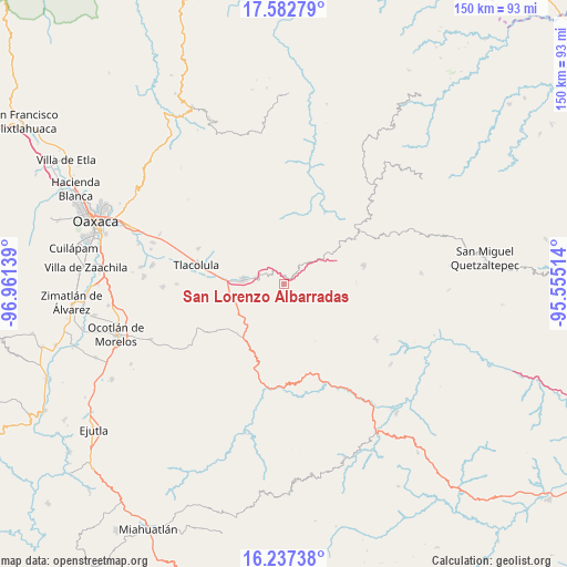
San Lorenzo Albarradas GPS coordinates[2]
16° 54' 40.644" North, 96° 15' 29.736" West
| Map corner | latitude | longitude |
|---|---|---|
| Upper-left | 17.58279°, | -96.96139° |
| Center: | 16.91129°, | -96.25826° |
| Lower-right: | 16.23738°, | -95.55514° |
| Map W x H: | 149.6×149.6 km | = 93×93mi |
| max Lat: | 32.7° ⇑90.2% North |
| San Lorenzo Albarradas: | 16.91129° |
| min Lat: | ⇓9.8% South 14.53588° |
| min Long | San Lorenzo Alb | max Long |
| -117.105° | -96.25826° | -86.73105° |
| W 81.1%⇐ | ⇒18.9% E |
Elevation
Elevation of San Lorenzo Albarradas is 1824 m = 5984 ft, and this is 570.3 m = 1871 ft above average elevation for this country.
| Max E: |
3497 m = 11473 ft | 35.2% |
| San Lorenzo Albarradas | 1824 m 5984 ft | |
| Avg. | 1253.7 m = 4113 ft | |
Min E: |
-1 m = -3 ft | 64.8% |
See also: Mexico elevation on elevation.city.
Geographical zone
San Lorenzo Albarradas is located in North Torrid zone (between Equator and Tropic of Cancer). Distance of this Northern Tropic circle is 725.6 km =450.9 mi to North.| Distance of | km | miles | from San Lorenzo Albarradas |
|---|---|---|---|
| North Pole | 8126.7 | 5049.7 | to North |
| Arctic Circle | 5520.8 | 3430.5 | to North |
| Tropic Cancer | 725.6 | 450.9 | to North |
| Equator | 1880.4 | 1168.4 | to South |


Nearby cities:
15 places around San Lorenzo Albarradas: (largest is in red/bold)
• Albarradas
18.4 km =11.4 mi,  19°
19°
• El Duraznal
16.4 km =10.2 mi,  35°
35°
• Lachicocana
19.7 km =12.2 mi,  31°
31°
• Llano Crucero
19.2 km =11.9 mi,  89°
89°
• San Baltazar Guelavila
13.7 km =8.5 mi,  201°
201°
• San Dionisio Ocotepec
18.6 km =11.6 mi,  230°
230°
• San Juan del Río
10.9 km =6.8 mi,  106°
106°
• San Miguel del Valle
20.8 km =12.9 mi,  305°
305°
• San Pablo Villa de Mitla
10.9 km =6.8 mi,  276°
276°
• Santa María Albarradas
9.4 km =5.8 mi,  50°
50°
• Santiago Matatlán
14.2 km =8.8 mi,  248°
248°
• Santo Tomás de Arriba
15.1 km =9.4 mi,  171°
171°
• Unión Zapata
16.5 km =10.3 mi,  272°
272°
• Villa Díaz Ordaz
20.8 km =12.9 mi,  296°
296°
• Xaaga
7.4 km =4.6 mi,  263°
263°
Sources, notices
• [Note1] Compared only with cities in Mexico existing in our database
• [Src1] Map data: © OpenStreetMap contributors (CC-BY-SA)
• [Src2] Other city data from geonames.org with taken over terms of usage.
• [Src3] Geographical zone / Annual Mean Temperature by Robert A. Rohde @ Wikipedia
