Tlacoatzintepec geodata
Tlacoatzintepec (Oaxaca) is a seat of a second-order administrative division; located in Mexico in America/Mexico_City (GMT-6) time zone. With population of 1,103 people, there are 7887 cities with bigger population in this country. Compared to other cities in Mexico, 80% of cities are located further ↑North; 79.2% of cities are located further ←West and 67.6% of cities have higher elevation than Tlacoatzintepec. Note1


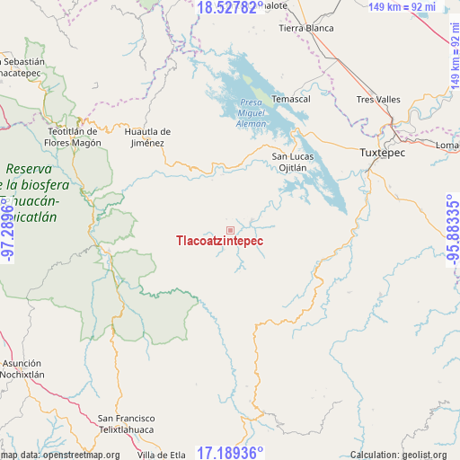
Tlacoatzintepec GPS coordinates[2]
17° 51' 35.46" North, 96° 35' 11.292" West
| Map corner | latitude | longitude |
|---|---|---|
| Upper-left | 18.52782°, | -97.2896° |
| Center: | 17.85985°, | -96.58647° |
| Lower-right: | 17.18936°, | -95.88335° |
| Map W x H: | 148.8×148.8 km | = 92.5×92.5mi |
| max Lat: | 32.7° ⇑80% North |
| Tlacoatzintepec: | 17.85985° |
| min Lat: | ⇓20% South 14.53588° |
| min Long | Tlacoatzintepec | max Long |
| -117.105° | -96.58647° | -86.73105° |
| W 79.2%⇐ | ⇒20.8% E |
Elevation
Elevation of Tlacoatzintepec is 548 m = 1798 ft, and this is 705.7 m = 2315 ft below average elevation for this country.
| Max E: |
3497 m = 11473 ft | 67.6% |
| Avg. | 1253.7 m = 4113 ft | |
| Tlacoatzintepec | 548 m = 1798 ft | |
Min E: |
-1 m = -3 ft | 32.4% |
See also: Mexico elevation on elevation.city.
Geographical zone
Tlacoatzintepec is located in North Torrid zone (between Equator and Tropic of Cancer). Distance of this Northern Tropic circle is 620.1 km =385.3 mi to North.| Distance of | km | miles | from Tlacoatzintepec |
|---|---|---|---|
| North Pole | 8021.2 | 4984.1 | to North |
| Arctic Circle | 5415.3 | 3364.9 | to North |
| Tropic Cancer | 620.1 | 385.3 | to North |
| Equator | 1985.8 | 1233.9 | to South |


Nearby cities:
15 places around Tlacoatzintepec: (largest is in red/bold)
• Colonia Ampliación Aeropuerto
8.4 km =5.2 mi,  63°
63°
• Flor Batavia
15.6 km =9.7 mi,  27°
27°
• Loma Naranja
20.1 km =12.5 mi,  357°
357°
• Paso Escaleras
12.8 km =8 mi, 58°
• San Alejo el Progreso
14.9 km =9.3 mi,  281°
281°
• San Andrés Teotilalpam
12.8 km =8 mi,  324°
324°
• San Felipe Usila
7.2 km =4.5 mi, 64°
• San Juan Sautla
9.3 km =5.8 mi,  268°
268°
• San Juan Zapotitlán
6.4 km =4 mi,  199°
199°
• San Pedro Sochiápam
8.8 km =5.5 mi,  246°
246°
• San Pedro Teutila
18.2 km =11.3 mi, 316°
• Santa María Tlalixtac
18.8 km =11.7 mi,  301°
301°
• Santiago Quetzalapa
5.4 km =3.4 mi,  241°
241°
• Santiago Tlatepusco
8.9 km =5.5 mi,  115°
115°
• Santo Domingo del Río
20.1 km =12.5 mi,  11°
11°
Sources, notices
• [Note1] Compared only with cities in Mexico existing in our database
• [Src1] Map data: © OpenStreetMap contributors (CC-BY-SA)
• [Src2] Other city data from geonames.org with taken over terms of usage.
• [Src3] Geographical zone / Annual Mean Temperature by Robert A. Rohde @ Wikipedia
