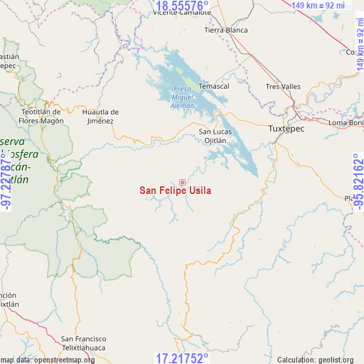
San Felipe Usila geodata
San Felipe Usila (Oaxaca) is a seat of a second-order administrative division; located in Mexico in America/Mexico_City (GMT-6) time zone. With population of 4,838 people, there are 1913 cities with bigger population in this country. Compared to other cities in Mexico, 79.8% of cities are located further ↑North; 79.6% of cities are located further ←West and 78.2% of cities have higher elevation than San Felipe Usila. Note1


San Felipe Usila GPS coordinates[2]
17° 53' 16.44" North, 96° 31' 29.064" West
| Map corner | latitude | longitude |
|---|---|---|
| Upper-left | 18.55576°, | -97.22787° |
| Center: | 17.8879°, | -96.52474° |
| Lower-right: | 17.21752°, | -95.82162° |
| Map W x H: | 148.8×148.8 km | = 92.5×92.5mi |
| max Lat: | 32.7° ⇑79.8% North |
| San Felipe Usila: | 17.8879° |
| min Lat: | ⇓20.2% South 14.53588° |
| min Long | San Felipe Usil | max Long |
| -117.105° | -96.52474° | -86.73105° |
| W 79.6%⇐ | ⇒20.4% E |
Elevation
Elevation of San Felipe Usila is 126 m = 413 ft, and this is 1127.7 m = 3700 ft below average elevation for this country.
| Max E: |
3497 m = 11473 ft | 78.2% |
| Avg. | 1253.7 m = 4113 ft | |
| San Felipe Usila | 126 m = 413 ft | |
Min E: |
-1 m = -3 ft | 21.8% |
See also: Mexico elevation on elevation.city.
Geographical zone
San Felipe Usila is located in North Torrid zone (between Equator and Tropic of Cancer). Distance of this Northern Tropic circle is 617 km =383.4 mi to North.| Distance of | km | miles | from San Felipe Usila |
|---|---|---|---|
| North Pole | 8018.1 | 4982.2 | to North |
| Arctic Circle | 5412.2 | 3363 | to North |
| Tropic Cancer | 617 | 383.4 | to North |
| Equator | 1988.9 | 1235.8 | to South |


Nearby cities:
15 places around San Felipe Usila: (largest is in red/bold)
• Colonia Ampliación Aeropuerto
1.1 km =0.7 mi,  57°
57°
• Flor Batavia
10.8 km =6.7 mi,  3°
3°
• Loma Naranja
18.5 km =11.5 mi,  336°
336°
• Loma de Cedro
16.9 km =10.5 mi,  20°
20°
• Paso Escaleras
5.6 km =3.5 mi,  50°
50°
• San Andrés Teotilalpam
15.7 km =9.8 mi,  297°
297°
• San Juan Sautla
16.2 km =10.1 mi,  258°
258°
• San Juan Zapotitlán
12.6 km =7.8 mi,  223°
223°
• San Pedro Sochiápam
16.1 km =10 mi,  245°
245°
• Santiago Quetzalapa
12.7 km =7.9 mi,  243°
243°
• Santiago Tlatepusco
7.1 km =4.4 mi,  167°
167°
• Santo Domingo del Río
16.7 km =10.4 mi,  351°
351°
• Santo Tomás
17.2 km =10.7 mi, 3°
• Tlacoatzintepec
7.2 km =4.5 mi, 244°
• Vista Hermosa
17.5 km =10.9 mi,  26°
26°
Sources, notices
• [Note1] Compared only with cities in Mexico existing in our database
• [Src1] Map data: © OpenStreetMap contributors (CC-BY-SA)
• [Src2] Other city data from geonames.org with taken over terms of usage.
• [Src3] Geographical zone / Annual Mean Temperature by Robert A. Rohde @ Wikipedia
