San Jerónimo Silacayoapilla geodata
San Jerónimo Silacayoapilla (Oaxaca) is a seat of a second-order administrative division; located in Mexico in America/Mexico_City (GMT-6) time zone. With population of 903 people, there are 9658 cities with bigger population in this country. Compared to other cities in Mexico, 80.4% of cities are located further ↑North; 65.5% of cities are located further ←West and 58.9% of cities have lower elevation than San Jerónimo Silacayoapilla. Note1
Current local time in San Jerónimo Silacayoapilla:
08:28 AM, WednesdayDifference from your time zone: hours


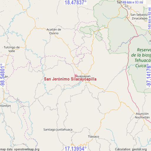
San Jerónimo Silacayoapilla GPS coordinates[2]
17° 48' 36.756" North, 97° 50' 41.568" West
| Map corner | latitude | longitude |
|---|---|---|
| Upper-left | 18.47837°, | -98.54801° |
| Center: | 17.81021°, | -97.84488° |
| Lower-right: | 17.13954°, | -97.14176° |
| Map W x H: | 148.9×148.9 km | = 92.5×92.5mi |
| max Lat: | 32.7° ⇑80.4% North |
| San Jerónimo Silacayoapilla: | 17.81021° |
| min Lat: | ⇓19.6% South 14.53588° |
| min Long | San Jerónimo S | max Long |
| -117.105° | -97.84488° | -86.73105° |
| W 65.5%⇐ | ⇒34.5% E |
Elevation
Elevation of San Jerónimo Silacayoapilla is 1706 m = 5597 ft, and this is 452.3 m = 1484 ft above average elevation for this country.
| Max E: |
3497 m = 11473 ft | 41.1% |
| San Jerónimo Silacayoapilla | 1706 m 5597 ft | |
| Avg. | 1253.7 m = 4113 ft | |
Min E: |
-1 m = -3 ft | 58.9% |
See also: Mexico elevation on elevation.city.
Geographical zone
San Jerónimo Silacayoapilla is located in North Torrid zone (between Equator and Tropic of Cancer). Distance of this Northern Tropic circle is 625.6 km =388.7 mi to North.| Distance of | km | miles | from San Jerónimo Silacayoapilla |
|---|---|---|---|
| North Pole | 8026.8 | 4987.6 | to North |
| Arctic Circle | 5420.9 | 3368.4 | to North |
| Tropic Cancer | 625.6 | 388.7 | to North |
| Equator | 1980.3 | 1230.5 | to South |


Nearby cities:
15 places around San Jerónimo Silacayoapilla: (largest is in red/bold)
• Acatilma
4.1 km =2.5 mi,  63°
63°
• Ciudad de Huajuapan de León
6.9 km =4.3 mi,  92°
92°
• Colonia Buena Vista
3.5 km =2.2 mi, 62°
• El Molino
10.5 km =6.5 mi,  111°
111°
• La Estancia
7.7 km =4.8 mi,  104°
104°
• La Junta
10.7 km =6.6 mi,  79°
79°
• Los Naranjos [Fraccionamiento]
7.7 km =4.8 mi, 110°
• San Francisco Yosocuta
7.6 km =4.7 mi,  158°
158°
• San Marcos Arteaga
9.9 km =6.2 mi,  189°
189°
• Santiago Chilixtlahuaca
11.9 km =7.4 mi,  333°
333°
• Santiago Huajolotitlán
12 km =7.5 mi, 80°
• Santo Domingo Yolotepec
11.6 km =7.2 mi,  271°
271°
• Saucitlán de Morelos
3.3 km =2.1 mi, 162°
• Vista Hermosa
9.4 km =5.8 mi, 99°
• Zapotitlán Palmas
9.3 km =5.8 mi,  17°
17°
Sources, notices
• [Note1] Compared only with cities in Mexico existing in our database
• [Src1] Map data: © OpenStreetMap contributors (CC-BY-SA)
• [Src2] Other city data from geonames.org with taken over terms of usage.
• [Src3] Geographical zone / Annual Mean Temperature by Robert A. Rohde @ Wikipedia
