Acatilma geodata
Acatilma (Oaxaca) is a populated place; located in Mexico in America/Mexico_City (GMT-6) time zone. With population of 812 people, there are 10760 cities with bigger population in this country. Compared to other cities in Mexico, 80.3% of cities are located further ↑North; 66% of cities are located further ←West and 63.7% of cities have lower elevation than Acatilma. Note1


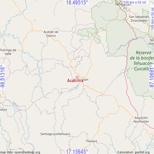
Acatilma GPS coordinates[2]
17° 49' 37.416" North, 97° 48' 36.108" West
| Map corner | latitude | longitude |
|---|---|---|
| Upper-left | 18.49515°, | -98.51316° |
| Center: | 17.82706°, | -97.81003° |
| Lower-right: | 17.15645°, | -97.10691° |
| Map W x H: | 148.8×148.9 km | = 92.5×92.5mi |
| max Lat: | 32.7° ⇑80.3% North |
| Acatilma: | 17.82706° |
| min Lat: | ⇓19.7% South 14.53588° |
| min Long | Acatilma | max Long |
| -117.105° | -97.81003° | -86.73105° |
| W 66%⇐ | ⇒34% E |
Elevation
Elevation of Acatilma is 1795 m = 5889 ft, and this is 541.3 m = 1776 ft above average elevation for this country.
| Max E: |
3497 m = 11473 ft | 36.3% |
| Acatilma | 1795 m 5889 ft | |
| Avg. | 1253.7 m = 4113 ft | |
Min E: |
-1 m = -3 ft | 63.7% |
See also: Mexico elevation on elevation.city.
Geographical zone
Acatilma is located in North Torrid zone (between Equator and Tropic of Cancer). Distance of this Northern Tropic circle is 623.7 km =387.5 mi to North.| Distance of | km | miles | from Acatilma |
|---|---|---|---|
| North Pole | 8024.9 | 4986.4 | to North |
| Arctic Circle | 5419 | 3367.2 | to North |
| Tropic Cancer | 623.7 | 387.5 | to North |
| Equator | 1982.2 | 1231.7 | to South |


Nearby cities:
15 places around Acatilma: (largest is in red/bold)
• Ciudad de Huajuapan de León
3.9 km =2.4 mi,  123°
123°
• Colonia Buena Vista
0.7 km =0.4 mi,  244°
244°
• Corral de Piedra
11.4 km =7.1 mi,  137°
137°
• El Molino
8.4 km =5.2 mi,  133°
133°
• La Estancia
5.4 km =3.4 mi, 134°
• La Junta
6.8 km =4.2 mi,  89°
89°
• Los Naranjos [Fraccionamiento]
5.8 km =3.6 mi, 142°
• San Francisco Yosocuta
9 km =5.6 mi,  185°
185°
• San Jerónimo Silacayoapilla
4.1 km =2.5 mi, 243°
• San Sebastián Progreso
12.7 km =7.9 mi,  97°
97°
• Santiago Chilixtlahuaca
12.6 km =7.8 mi,  314°
314°
• Santiago Huajolotitlán
8.2 km =5.1 mi, 89°
• Saucitlán de Morelos
5.7 km =3.5 mi,  207°
207°
• Vista Hermosa
6.6 km =4.1 mi, 121°
• Zapotitlán Palmas
7 km =4.3 mi,  352°
352°
Sources, notices
• [Note1] Compared only with cities in Mexico existing in our database
• [Src1] Map data: © OpenStreetMap contributors (CC-BY-SA)
• [Src2] Other city data from geonames.org with taken over terms of usage.
• [Src3] Geographical zone / Annual Mean Temperature by Robert A. Rohde @ Wikipedia
