San José Tepoxtla geodata
San José Tepoxtla (Tlaxcala) is a populated place; located in Mexico in America/Mexico_City (GMT-6) time zone. With population of 638 people, there are 13580 cities with bigger population in this country. Compared to other cities in Mexico, 56.7% of cities are located further ↑North; 61.8% of cities are located further ←West and 90.1% of cities have lower elevation than San José Tepoxtla. Note1


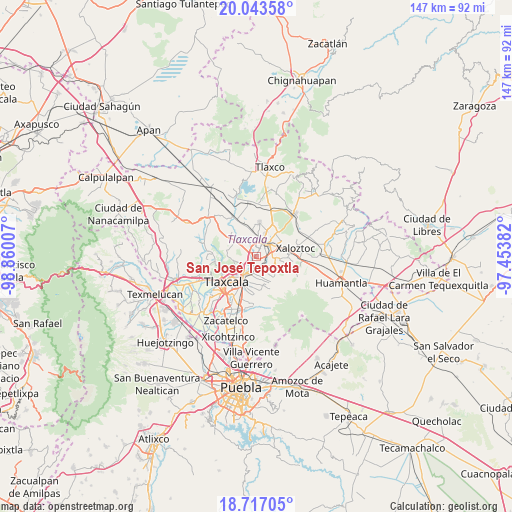
San José Tepoxtla GPS coordinates[2]
19° 22' 54.012" North, 98° 9' 24.984" West
| Map corner | latitude | longitude |
|---|---|---|
| Upper-left | 20.04358°, | -98.86007° |
| Center: | 19.38167°, | -98.15694° |
| Lower-right: | 18.71705°, | -97.45382° |
| Map W x H: | 147.5×147.5 km | = 91.7×91.7mi |
| max Lat: | 32.7° ⇑56.7% North |
| San José Tepoxtla: | 19.38167° |
| min Lat: | ⇓43.3% South 14.53588° |
| min Long | San José Tepox | max Long |
| -117.105° | -98.15694° | -86.73105° |
| W 61.8%⇐ | ⇒38.2% E |
Elevation
Elevation of San José Tepoxtla is 2411 m = 7910 ft, and this is 1157.3 m = 3797 ft above average elevation for this country.
| Max E: |
3497 m = 11473 ft | 9.9% |
| San José Tepoxtla | 2411 m 7910 ft | |
| Avg. | 1253.7 m = 4113 ft | |
Min E: |
-1 m = -3 ft | 90.1% |
See also: Mexico elevation on elevation.city.
Geographical zone
San José Tepoxtla is located in North Torrid zone (between Equator and Tropic of Cancer). Distance of this Northern Tropic circle is 450.9 km =280.2 mi to North.| Distance of | km | miles | from San José Tepoxtla |
|---|---|---|---|
| North Pole | 7852 | 4879 | to North |
| Arctic Circle | 5246.1 | 3259.8 | to North |
| Tropic Cancer | 450.9 | 280.2 | to North |
| Equator | 2155 | 1339.1 | to South |


Nearby cities:
15 places around San José Tepoxtla: (largest is in red/bold)
• Amaxac de Guerrero
4.2 km =2.6 mi,  200°
200°
• Apizaco
3.8 km =2.4 mi,  21°
21°
• Barrio de Atencingo
2.2 km =1.4 mi,  313°
313°
• Belén Atzitzimititlán
5.2 km =3.2 mi,  221°
221°
• Hualcaltzinco
2.1 km =1.3 mi,  351°
351°
• San Benito Xaltocan
2.9 km =1.8 mi,  338°
338°
• San Francisco Tlacuilohcan
4.4 km =2.7 mi,  300°
300°
• San Lucas Tlacochcalco
4.5 km =2.8 mi,  165°
165°
• San Matías Tepetomatitlán
5 km =3.1 mi,  232°
232°
• San Miguel Contla
3.4 km =2.1 mi,  131°
131°
• Santa Anita Huiloac
1.6 km =1 mi,  61°
61°
• Santa Cruz Tlaxcala
3.1 km =1.9 mi, 167°
• Santa María Atlihuetzian
2.2 km =1.4 mi,  256°
256°
• Yauhquemehcan
3.9 km =2.4 mi,  316°
316°
• Zimatepec
4.5 km =2.8 mi, 349°
Sources, notices
• [Note1] Compared only with cities in Mexico existing in our database
• [Src1] Map data: © OpenStreetMap contributors (CC-BY-SA)
• [Src2] Other city data from geonames.org with taken over terms of usage.
• [Src3] Geographical zone / Annual Mean Temperature by Robert A. Rohde @ Wikipedia
