San Cristobal geodata
San Cristobal (Hidalgo) is a populated place; located in Mexico in America/Mexico_City (GMT-6) time zone. With population of 622 people, there are 13890 cities with bigger population in this country. Compared to other cities in Mexico, 52.7% of cities are located further ↑North; 55.5% of cities are located further ←West and 97.2% of cities have lower elevation than San Cristobal. Note1


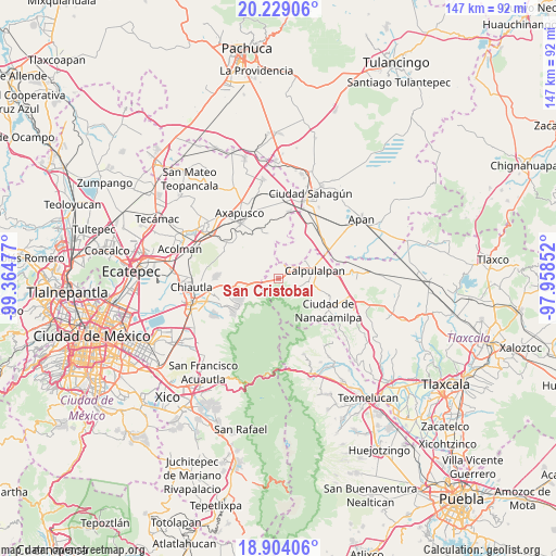
San Cristobal GPS coordinates[2]
19° 34' 4.512" North, 98° 39' 41.904" West
| Map corner | latitude | longitude |
|---|---|---|
| Upper-left | 20.22906°, | -99.36477° |
| Center: | 19.56792°, | -98.66164° |
| Lower-right: | 18.90406°, | -97.95852° |
| Map W x H: | 147.3×147.3 km | = 91.5×91.5mi |
| max Lat: | 32.7° ⇑52.7% North |
| San Cristobal: | 19.56792° |
| min Lat: | ⇓47.3% South 14.53588° |
| min Long | San Cristobal | max Long |
| -117.105° | -98.66164° | -86.73105° |
| W 55.5%⇐ | ⇒44.5% E |
Elevation
Elevation of San Cristobal is 2694 m = 8839 ft, and this is 1440.3 m = 4725 ft above average elevation for this country.
| Max E: |
3497 m = 11473 ft | 2.8% |
| San Cristobal | 2694 m 8839 ft | |
| Avg. | 1253.7 m = 4113 ft | |
Min E: |
-1 m = -3 ft | 97.2% |
See also: Mexico elevation on elevation.city.
Geographical zone
San Cristobal is located in North Torrid zone (between Equator and Tropic of Cancer). Distance of this Northern Tropic circle is 430.2 km =267.3 mi to North.| Distance of | km | miles | from San Cristobal |
|---|---|---|---|
| North Pole | 7831.3 | 4866.1 | to North |
| Arctic Circle | 5225.4 | 3246.9 | to North |
| Tropic Cancer | 430.2 | 267.3 | to North |
| Equator | 2175.7 | 1351.9 | to South |


Nearby cities:
15 places around San Cristobal: (largest is in red/bold)
• Calpulalpan
9.9 km =6.2 mi,  76°
76°
• La Soledad
5.7 km =3.5 mi,  125°
125°
• Mazapa
11.4 km =7.1 mi,  105°
105°
• San Andrés de las Peras
13.7 km =8.5 mi,  264°
264°
• San Bernardo Tlalmimilolpan
13.8 km =8.6 mi,  267°
267°
• San Felipe Sultepec
5.5 km =3.4 mi,  62°
62°
• San Jerónimo Amanalco
11.4 km =7.1 mi,  240°
240°
• San Juan Totolapan
8 km =5 mi, 238°
• San Marcos Guaquilpan
4.8 km =3 mi,  45°
45°
• San Martín Ahuatepec
14.4 km =8.9 mi,  331°
331°
• San Pedro Chiautzingo
13.3 km =8.3 mi, 271°
• Santa Bárbara
14.6 km =9.1 mi,  41°
41°
• Santa Catarina del Monte
14.9 km =9.3 mi,  231°
231°
• Santa María Tecuanulco
12.5 km =7.8 mi, 237°
• Santiago Cuaula
3.9 km =2.4 mi,  19°
19°
Sources, notices
• [Note1] Compared only with cities in Mexico existing in our database
• [Src1] Map data: © OpenStreetMap contributors (CC-BY-SA)
• [Src2] Other city data from geonames.org with taken over terms of usage.
• [Src3] Geographical zone / Annual Mean Temperature by Robert A. Rohde @ Wikipedia
